Pho Si Suwan district
District in Sisaket, Thailand From Wikipedia, the free encyclopedia
District in Sisaket, Thailand From Wikipedia, the free encyclopedia
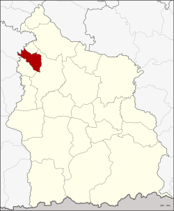
Pho Si Suwan (Thai: โพธิ์ศรีสุวรรณ, pronounced [pʰōː sǐː sù.wān]) is a district (amphoe) in the northwestern part of Sisaket province, northeastern Thailand.
Pho Si Suwan
โพธิ์ศรีสุวรรณ | |
|---|---|
 Karnkusol Wat Bandod School, a local school | |
 District location in Sisaket province | |
| Coordinates: 15°13′54″N 104°4′36″E | |
| Country | Thailand |
| Province | Sisaket |
| Seat | Dot |
| Area | |
| • Total | 111.1 km2 (42.9 sq mi) |
| Population (2005) | |
| • Total | 23,519 |
| • Density | 211.7/km2 (548/sq mi) |
| Time zone | UTC+7 (ICT) |
| Postal code | 33120 |
| Geocode | 3321 |
The minor district (king amphoe) was established on 30 April 1994, when it was split off from Uthumphon Phisai district.[1]
On 15 May 2007, all 81 minor districts were upgraded to full districts.[2] On 24 August the upgrade became official.[3]
Neighboring districts are (from the north clockwise) Bueng Bun, Uthumphon Phisai, and Mueang Chan of Sisaket Province, and Rattanaburi of Surin province.
The district is divided into five sub-districts (tambons), which are further subdivided into 80 villages (mubans). There are no municipal (thesaban) areas. There are five tambon administrative organizations (TAO).
| No. | Name | Thai name | Villages | Pop. |
|---|---|---|---|---|
| 1. | Dot | โดด | 25 | 7,952 |
| 2. | Siao | เสียว | 17 | 4,455 |
| 3. | Nong Ma | หนองม้า | 12 | 3,519 |
| 4. | Phue Yai | ผือใหญ่ | 14 | 4,568 |
| 5. | I Se | อีเซ | 12 | 3,025 |
Seamless Wikipedia browsing. On steroids.
Every time you click a link to Wikipedia, Wiktionary or Wikiquote in your browser's search results, it will show the modern Wikiwand interface.
Wikiwand extension is a five stars, simple, with minimum permission required to keep your browsing private, safe and transparent.