Phakding
Village in Province No. 1, Nepal From Wikipedia, the free encyclopedia
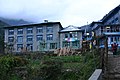
Phakding is a small village in the Khumbu region of Nepal. It lies in the Dudh Kosi river valley just north of Lukla and south of Monjo, at an altitude of 2,610 m.[1][2][3] It has been a UNESCO World Heritage Site since 1979. Phakding has a population of 550 locals, mostly Sherpa and Tamang. All of these people belong to Tibetan Buddhism and pray in a small Gompa at the centre of the village. [4]
Phadking | |
|---|---|
 Trail exiting the village of Phakding leading to Lukla. | |
 Phadking Location in Nepal  Phadking Phadking (Nepal) | |
| Coordinates: 27°45′N 86°43′E | |
| Country | Nepal |
| Province | Province No. 1 |
| District | Solukhumbu District |
| Rural municipality | Khumbu Pasanglhamu |
| Government | |
| • Type | Ward division |
| Elevation | 2,610 m (8,560 ft) |
| Time zone | UTC+5:45 (Nepal Time) |
| Area code | 038 |
The trail starts at Lukla and Phakding is often the main stopping point for trekkers on their way to Mount Everest via the Gokyo Ri route or Tengboche route.[2]
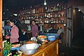
The primary function of the village is to support the tourism industry and as such consists of a number of guesthouses.[2] There are around 25 hotels ranging from basic homestay to 4-start Luxury hotels in Phakding. The village can accommodate a maximum of 300 tourists at one time.
- Phakding


Climate
| Climate data for Phakding (Chaurikharka), elevation 2,619 m (8,593 ft) | |||||||||||||
|---|---|---|---|---|---|---|---|---|---|---|---|---|---|
| Month | Jan | Feb | Mar | Apr | May | Jun | Jul | Aug | Sep | Oct | Nov | Dec | Year |
| Mean daily maximum °C (°F) | 9.8 (49.6) |
11.0 (51.8) |
13.6 (56.5) |
18.1 (64.6) |
19.2 (66.6) |
19.5 (67.1) |
19.2 (66.6) |
19.6 (67.3) |
18.3 (64.9) |
17.5 (63.5) |
14.0 (57.2) |
11.3 (52.3) |
15.9 (60.7) |
| Daily mean °C (°F) | 4.0 (39.2) |
5.4 (41.7) |
8.3 (46.9) |
12.1 (53.8) |
13.6 (56.5) |
15.3 (59.5) |
15.6 (60.1) |
15.6 (60.1) |
14.5 (58.1) |
12.3 (54.1) |
8.1 (46.6) |
5.4 (41.7) |
10.9 (51.5) |
| Mean daily minimum °C (°F) | −1.5 (29.3) |
−0.3 (31.5) |
3.0 (37.4) |
6.0 (42.8) |
8.3 (46.9) |
11.3 (52.3) |
12.1 (53.8) |
11.6 (52.9) |
10.6 (51.1) |
7.0 (44.6) |
2.2 (36.0) |
−0.5 (31.1) |
5.8 (42.5) |
| Average precipitation mm (inches) | 18.3 (0.72) |
30.3 (1.19) |
27.0 (1.06) |
60.1 (2.37) |
106.7 (4.20) |
321.5 (12.66) |
583.1 (22.96) |
570.1 (22.44) |
297.7 (11.72) |
63.6 (2.50) |
13.0 (0.51) |
14.7 (0.58) |
2,106.1 (82.91) |
| Source 1: FAO[5] | |||||||||||||
| Source 2: Agricultural Extension in South Asia (precipitation 1976–2005)[6] | |||||||||||||
See also
References
Wikiwand - on
Seamless Wikipedia browsing. On steroids.