Top Qs
Timeline
Chat
Perspective
Penycloddiau
Hill in Flintshire, Wales From Wikipedia, the free encyclopedia

Remove ads
Penycloddiau is a hill in Flintshire, Wales, and one of five Marilyns in the Clwydian Range.


The hill, like Foel Fenlli and Moel Arthur to the south, has an Iron Age hillfort at its summit.[2] It covers 26 hectares (64 acres) making it one of the largest hillforts in Wales.[2] In 2017, excavations by the Clywdian Range Archaeology Group (CRAG) unearthed a significant number of 4,000-year-old stone tools from the Bronze Age, the discovery indicates human activity occurred much earlier than first thought in the area.[3]
Penycloddiau is crossed by the Offa's Dyke Path and the Clwydian Way, two long distance footpaths that traverse the hills in this area. A free car park exists at the bwlch between Penycloddiau and Moel Arthur, where two footpaths lead to the summit.[4]
Remove ads
Gallery
 A view of the outer defence wall at Penycloddiau hill fort
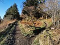 The Offa's Dyke Path climbs Penycloddiau from the east


See also
References
Further reading
External links
Wikiwand - on
Seamless Wikipedia browsing. On steroids.
Remove ads