Penguin Peak
Mountain in Alaska, U.S. From Wikipedia, the free encyclopedia

Penguin Peak is a 4,331-foot (1,320 m) mountain summit located in the Chugach Mountains, in Anchorage Municipality in the U.S. state of Alaska. The peak is situated in Chugach State Park, 30 mi (48 km) southeast of downtown Anchorage, and 8 mi (13 km) east of the Alyeska Resort and Girdwood area. The peak is the dominant feature along the north shore of Turnagain Arm when traveling the Seward Highway, and the summit offers a good view of Mount Alpenglow, 6 mi (10 km) directly across Turnagain Arm to the south.
| Penguin Peak | |
|---|---|
.jpg) Penguin Peak seen from Bird Ridge | |
| Highest point | |
| Elevation | 4,331 ft (1,320 m)[1] |
| Prominence | 1,437 ft (438 m)[2] |
| Coordinates | 60°57′55″N 149°22′31″W[1] |
| Geography | |
 Penguin Peak Location in Alaska | |
 | |
| Interactive map of Penguin Peak | |
| Location | Chugach National Forest Anchorage Municipality, Alaska United States |
| Parent range | Chugach Mountains |
| Topo map | USGS Seward D-7 |
| Climbing | |
| Easiest route | Hiking class 2 |
Climate
Based on the Köppen climate classification, Penguin Peak is located in a subarctic climate zone with cold, snowy winters, and mild summers.[3] Weather systems coming off the Gulf of Alaska are forced upwards by the Chugach Mountains (orographic lift), causing heavy precipitation in the form of rainfall and snowfall. Temperatures can drop below −20 °C with wind chill factors below −30 °C. Precipitation runoff from the mountain drains into Penguin Creek and Turnagain Arm.
Gallery
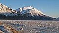 Penguin Peak seen from Seward Highway
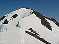 Summit detail
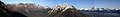 Panorama from Bird Ridge with Penguin Peak centered


See also
References
External links
Wikiwand - on
Seamless Wikipedia browsing. On steroids.