Parguera
Barrio of Lajas, Puerto Rico From Wikipedia, the free encyclopedia
Barrio of Lajas, Puerto Rico From Wikipedia, the free encyclopedia
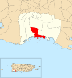
Parguera is a barrio in the municipality of Lajas, Puerto Rico with a population of 2,082 in 2010.[3] La Parguera is the main settlement of the barrio, often referred to as Poblado de la Parguera. Parguera is home to La Parguera Nature Reserve, which encompasses the bioluminescent bay, its surrounding mangrove forests, wetlands and a number of keys such as Mata La Gata and Cayo Enrique. The name Parguera derives from pargo, the local name for the Northern red snapper (Lutjanus campechanus).[4]
Parguera | |
|---|---|
Barrio | |
 On the water in Parguera | |
 Location of Parguera within the municipality of Lajas shown in red | |
| Coordinates: 17°58′33″N 67°02′31″W[1] | |
| Commonwealth | |
| Municipality | |
| Area | |
| • Total | 7.34 sq mi (19.0 km2) |
| • Land | 4.02 sq mi (10.4 km2) |
| • Water | 3.32 sq mi (8.6 km2) |
| Elevation | 36 ft (11 m) |
| Population (2010) | |
| • Total | 2,082 |
| • Density | 519.2/sq mi (200.5/km2) |
| Source: 2010 Census | |
| Time zone | UTC−4 (AST) |
The settlement of La Parguera was established as a villa pesquera (fishing village) in 1825.[4]
Parguera was in Spain's gazetteers[5] until Puerto Rico was ceded by Spain in the aftermath of the Spanish–American War under the terms of the Treaty of Paris of 1898 and became an unincorporated territory of the United States. In 1899, the United States Department of War conducted a census of Puerto Rico finding that the combined population of Parguera and Costa barrios was 1,256.[6]
Parguera barrio is mainly known for La Parguera Bio Bay, a tourist spot from where sunset and night bioluminescent tours leave regularly. Tourists go out on a kayak or small boat at night to see the bay with its bioluminescent waters, caused by microorganisms called dinoflagellate and seen when the water is disturbed at night. A parador (country inn) called Parador Villa Parguera is located in Parguera.[12]
| Climate data for Parguera, Puerto Rico (1991–2020 normals, extremes 1959–present) | |||||||||||||
|---|---|---|---|---|---|---|---|---|---|---|---|---|---|
| Month | Jan | Feb | Mar | Apr | May | Jun | Jul | Aug | Sep | Oct | Nov | Dec | Year |
| Record high °F (°C) | 92 (33) |
93 (34) |
95 (35) |
96 (36) |
97 (36) |
97 (36) |
100 (38) |
98 (37) |
101 (38) |
103 (39) |
95 (35) |
94 (34) |
103 (39) |
| Mean daily maximum °F (°C) | 86.0 (30.0) |
85.8 (29.9) |
85.7 (29.8) |
86.7 (30.4) |
88.2 (31.2) |
89.8 (32.1) |
90.4 (32.4) |
90.6 (32.6) |
90.5 (32.5) |
90.0 (32.2) |
88.3 (31.3) |
87.5 (30.8) |
88.3 (31.3) |
| Daily mean °F (°C) | 78.0 (25.6) |
77.6 (25.3) |
78.0 (25.6) |
79.6 (26.4) |
81.5 (27.5) |
83.1 (28.4) |
83.2 (28.4) |
83.1 (28.4) |
83.3 (28.5) |
82.4 (28.0) |
80.7 (27.1) |
78.8 (26.0) |
80.8 (27.1) |
| Mean daily minimum °F (°C) | 70.0 (21.1) |
69.4 (20.8) |
70.3 (21.3) |
72.4 (22.4) |
74.8 (23.8) |
76.3 (24.6) |
75.9 (24.4) |
75.6 (24.2) |
76.1 (24.5) |
74.9 (23.8) |
73.0 (22.8) |
70.0 (21.1) |
73.2 (22.9) |
| Record low °F (°C) | 60 (16) |
50 (10) |
60 (16) |
58 (14) |
59 (15) |
67 (19) |
66 (19) |
62 (17) |
61 (16) |
66 (19) |
62 (17) |
60 (16) |
50 (10) |
| Average precipitation inches (mm) | 1.93 (49) |
1.86 (47) |
2.71 (69) |
3.57 (91) |
4.07 (103) |
2.54 (65) |
2.67 (68) |
4.32 (110) |
5.53 (140) |
6.26 (159) |
5.06 (129) |
1.96 (50) |
42.48 (1,079) |
| Source: NOAA[13][14] | |||||||||||||
Seamless Wikipedia browsing. On steroids.
Every time you click a link to Wikipedia, Wiktionary or Wikiquote in your browser's search results, it will show the modern Wikiwand interface.
Wikiwand extension is a five stars, simple, with minimum permission required to keep your browsing private, safe and transparent.