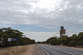
Panitya, Victoria
Town in Victoria, Australia From Wikipedia, the free encyclopedia
Town in Victoria, Australia From Wikipedia, the free encyclopedia
Panitya is a locality situated in the Sunraysia region of Victoria, Australia. The place by road, is situated about 23 kilometres east from Pinnaroo and 10 kilometres west from Carina on the Mallee Highway.
| Panitya Victoria | |||||||||||||||
|---|---|---|---|---|---|---|---|---|---|---|---|---|---|---|---|
 Entering Panitya | |||||||||||||||
| Coordinates | 35°14′10″S 140°59′30″E | ||||||||||||||
| Population | 65 (2016 census)[1] | ||||||||||||||
| Postcode(s) | 3512 | ||||||||||||||
| Elevation | 91 m (299 ft) | ||||||||||||||
| Location | |||||||||||||||
| LGA(s) | Rural City of Mildura | ||||||||||||||
| State electorate(s) | Mildura | ||||||||||||||
| Federal division(s) | Mallee | ||||||||||||||
| |||||||||||||||
Panitya is a railway station on the Ouyen to Pinnaroo line.
The Post Office opened in 1910 and was closed in 1975.[3]
The area of the locality contains a number of smaller areas, namely Panitya East which had a post office open from 1916 until 1933, Berrook which had a post office open from 1929 until 1935, Manya with a post office from 1928 until 1936, Sunset with a post office from 1921 until 1948 and, below the Mallee Highway, Ngallo.[3]
Seamless Wikipedia browsing. On steroids.
Every time you click a link to Wikipedia, Wiktionary or Wikiquote in your browser's search results, it will show the modern Wikiwand interface.
Wikiwand extension is a five stars, simple, with minimum permission required to keep your browsing private, safe and transparent.