Palominas, Arizona
CDP in Cochise County, Arizona From Wikipedia, the free encyclopedia
CDP in Cochise County, Arizona From Wikipedia, the free encyclopedia
Palominas is a census-designated place located along the San Pedro River in the southern portion of Cochise County in the state of Arizona, United States. Palominas is located very close to the community of Miracle Valley along Arizona State Highway 92. The population of Palominas as of the 2020 U.S. Census was 222.[3]
Palominas, Arizona | |
|---|---|
 San Pedro River | |
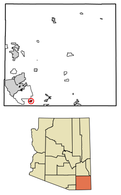
 Location of Palominas in Cochise County, Arizona. | |
| Coordinates: 31°22′47″N 110°07′27″W | |
| Country | United States |
| State | Arizona |
| County | Cochise |
| Area | |
• Total | 1.95 sq mi (5.05 km2) |
| • Land | 1.95 sq mi (5.04 km2) |
| • Water | 0.00 sq mi (0.01 km2) |
| Elevation | 4,242 ft (1,293 m) |
| Population (2020) | |
• Total | 222 |
| • Density | 114.02/sq mi (44.02/km2) |
| Time zone | UTC-7 (MST (no daylight saving time)) |
| ZIP code | 85615 |
| Area code | 520 |
| FIPS code | 04-52230 |
| GNIS feature ID | 2582839[2] |
| Website | www |
| Race | Number | Percentage |
|---|---|---|
| White (NH) | 171 | 77.03% |
| Black or African American (NH) | 4 | 1.8% |
| Native American or Alaska Native (NH) | 4 | 1.8% |
| Asian (NH) | 3 | 1.35% |
| Pacific Islander (NH) | 2 | 0.9% |
| Some Other Race (NH) | 4 | 1.8% |
| Mixed/Multi-Racial (NH) | 34 | 15.32% |
| Hispanic or Latino | 45 | 20.27% |
| Total | 222 |
Cochice Connection provides bus connections between Douglas, Bisbee, and Sierra Vista, with a stop in Palominas.[8]
Seamless Wikipedia browsing. On steroids.
Every time you click a link to Wikipedia, Wiktionary or Wikiquote in your browser's search results, it will show the modern Wikiwand interface.
Wikiwand extension is a five stars, simple, with minimum permission required to keep your browsing private, safe and transparent.