Pallabi Thana
Thana in Dhaka North City Corporation, Bangladesh From Wikipedia, the free encyclopedia
Thana in Dhaka North City Corporation, Bangladesh From Wikipedia, the free encyclopedia
Pallabi (Bengali: পল্লবী) is a thana of Dhaka District in the Division of Dhaka, Bangladesh. Its total area is 9.97 square kilometres (3.85 sq mi), located between 23°48' and 23°52' north latitudes and between 90°20' and 90°23' east longitudes.
This article has multiple issues. Please help improve it or discuss these issues on the talk page. (Learn how and when to remove these messages)
|
Pallabi Thana
পল্লবী থানা | |
|---|---|
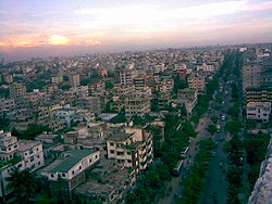
 Skyline of Pallabi, Bangladesh | |
 Expandable map of vicinity of Pallabi Thana | |
| Coordinates: 23.825°N 90.3694°E | |
| Country | |
| Division | Dhaka Division |
| District | Dhaka District |
| Established as a thana | 2005 |
| Area | |
| • Total | 9.97 km2 (3.85 sq mi) |
| Elevation | 23 m (75 ft) |
| Population | |
| • Total | 597,574 |
| • Density | 23,609/km2 (61,150/sq mi) |
| Time zone | UTC+6 (BST) |
| Postal code | 1221 |
| Area code | 02[3] |
There are different opinions on the origin of the name of Pallabi:

Pallabi is bounded by Turag River and Uttara Thana on the north, Mirpur Model Thana and Shah Ali Thana on the south, Bimanbandar Thana, Cantonment Thana and Kafrul Thana on the east, and Savar Upazila on the west. Its total area is 9.97 km².[4]
According to 2011 Census of Bangladesh, Pallabi Thana has a population of 596,835 with average household size of 4.2 members, and an average literacy rate of 70.6% vs national average of 51.8% literacy.[5]
Pallabi has one union/ward, 16+27 mauzas/mahallas, and no villages.
Seamless Wikipedia browsing. On steroids.
Every time you click a link to Wikipedia, Wiktionary or Wikiquote in your browser's search results, it will show the modern Wikiwand interface.
Wikiwand extension is a five stars, simple, with minimum permission required to keep your browsing private, safe and transparent.