Paisley, Ontario
Community in Ontario, Canada From Wikipedia, the free encyclopedia
Paisley is an unincorporated community and village in the municipality of Arran–Elderslie, Bruce County in Southwestern Ontario, Canada.[1][3][4][5] Paisley is defined by its position at the confluence of the Saugeen River and the Teeswater River, and at the junction of Bruce Roads 1, 11, and 3.
Paisley | |
---|---|
Community | |
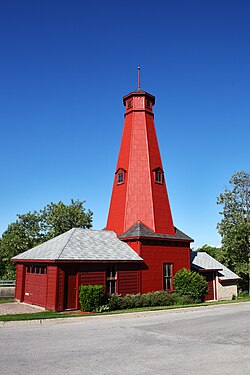
![]() Historic Hose Tower in Paisley, built in 1891 | |
Etymology: Named after Paisley, Renfrewshire | |
Coordinates: 44°18′27″N 81°16′27″W[1] | |
Country | Canada |
Province | Ontario |
County | Bruce County |
Municipality | Arran–Elderslie |
First settled | 1851 |
Elevation | 217 m (712 ft) |
Time zone | UTC-5 (Eastern Time Zone) |
• Summer (DST) | UTC-4 (Eastern Time Zone) |
Postal code | N0G 2N0 |
Area codes | 519, 226, 548 |
CGNDB key | FAXPT |
History
Paisley began with the settlement in 1851 of Simon Orchard and Samuel T. Rowe at the site of what would become the village of Paisley, later that year John Valentine, built a sawmill here. The village was named in 1856 after Paisley, Renfrewshire in Scotland.[6]
Notable persons
- Alexander James McPhail, an agricultural reformer, was born in Paisley in 1883.
- Marshall Kay, a paleontologist prominently involved with the study of continental drift, was born in Paisley in 1904.
- Isabella Valancy Crawford, a prolific Canadian author, lived in Paisley between 1857 and 1861.
Climate
Climate data for Paisley | |||||||||||||
---|---|---|---|---|---|---|---|---|---|---|---|---|---|
Month | Jan | Feb | Mar | Apr | May | Jun | Jul | Aug | Sep | Oct | Nov | Dec | Year |
Record high °C (°F) | 12.2 (54.0) |
14.0 (57.2) |
23.0 (73.4) |
28.5 (83.3) |
32.2 (90.0) |
33.9 (93.0) |
34.5 (94.1) |
35.0 (95.0) |
32.8 (91.0) |
27.2 (81.0) |
21.0 (69.8) |
18.5 (65.3) |
35.0 (95.0) |
Mean daily maximum °C (°F) | −3.2 (26.2) |
−2.6 (27.3) |
2.5 (36.5) |
10.2 (50.4) |
17.8 (64.0) |
22.1 (71.8) |
25.0 (77.0) |
24.0 (75.2) |
19.5 (67.1) |
12.8 (55.0) |
5.9 (42.6) |
−0.5 (31.1) |
11.1 (52.0) |
Daily mean °C (°F) | −7 (19) |
−6.9 (19.6) |
−2.2 (28.0) |
5.1 (41.2) |
11.5 (52.7) |
15.9 (60.6) |
18.9 (66.0) |
18.2 (64.8) |
14.1 (57.4) |
8.2 (46.8) |
2.5 (36.5) |
−3.8 (25.2) |
6.2 (43.2) |
Mean daily minimum °C (°F) | −10.7 (12.7) |
−11.3 (11.7) |
−6.8 (19.8) |
0.1 (32.2) |
5.2 (41.4) |
9.6 (49.3) |
12.7 (54.9) |
12.4 (54.3) |
8.8 (47.8) |
3.5 (38.3) |
−0.9 (30.4) |
−7.1 (19.2) |
1.3 (34.3) |
Record low °C (°F) | −37.2 (−35.0) |
−40.0 (−40.0) |
−33.0 (−27.4) |
−18.9 (−2.0) |
−6.1 (21.0) |
−2.2 (28.0) |
2.2 (36.0) |
0 (32) |
−5.5 (22.1) |
−8.3 (17.1) |
−17.5 (0.5) |
−31 (−24) |
−40 (−40) |
Average precipitation mm (inches) | 144 (5.7) |
93 (3.7) |
88.4 (3.48) |
70.3 (2.77) |
75.5 (2.97) |
76.4 (3.01) |
73.9 (2.91) |
101.2 (3.98) |
111 (4.4) |
98.2 (3.87) |
110.7 (4.36) |
150 (5.9) |
1,192.7 (46.96) |
Average rainfall mm (inches) | 18.4 (0.72) |
23.4 (0.92) |
50.7 (2.00) |
60.1 (2.37) |
75.4 (2.97) |
76.4 (3.01) |
73.9 (2.91) |
101.2 (3.98) |
111 (4.4) |
97.2 (3.83) |
74.3 (2.93) |
40.6 (1.60) |
802.6 (31.60) |
Average snowfall cm (inches) | 125.7 (49.5) |
69.6 (27.4) |
37.7 (14.8) |
10.3 (4.1) |
0.1 (0.0) |
0 (0) |
0 (0) |
0 (0) |
0 (0) |
1 (0.4) |
36.4 (14.3) |
109.4 (43.1) |
390.1 (153.6) |
Source: Environment Canada[7] |
References
External links
Wikiwand - on
Seamless Wikipedia browsing. On steroids.