Top Qs
Timeline
Chat
Perspective
Oppdal (village)
Village in Oppdal Municipality, Norway From Wikipedia, the free encyclopedia

Remove ads
ⓘ[3] (locally: Auna[4]) is the administrative centre of Oppdal Municipality in Trøndelag county, Norway. The village is located at the junction of the European route E06 and the Norwegian National Road 70. The villages of Vognillan, Fagerhaugen, and Driva are all located around Oppdal to the west, north, and south respectively.[4]


The 3.72-square-kilometre (920-acre) village has a population (2024) of 4,637 which gives the village a population density of 1,247 inhabitants per square kilometre (3,230/sq mi).[1]
The village of Oppdal is the site of the municipal government services as well as a school, mall, hotel, stores and businesses as well as the historic Oppdal Church. The Dovrebanen railway line passes through the village, stopping at the Oppdal Station.[4]
Remove ads
Name
The village (originally the parish) is named after the old Oppdal farm (Old Norse: Uppdalr) since the first Oppdal Church was built there. The first element is upp which means "upper". The last element is dalr which means "valley" or "dale". Historically, the name was also spelled Opdal.[5]
Notable people
Media gallery
 Oppdal kulturhus
 Skifer hotel
 Domus shopping mall
 Historic photo of the centre of Oppdal
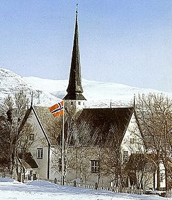


.JPG)


References
External links
Wikiwand - on
Seamless Wikipedia browsing. On steroids.
Remove ads