Top Qs
Timeline
Chat
Perspective
Olney-Oak Lane, Philadelphia
Neighborhood of Philadelphia in Philadelphia, Pennsylvania From Wikipedia, the free encyclopedia
Remove ads
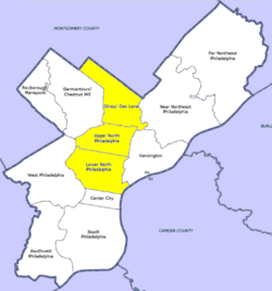
Olney-Oak Lane, Philadelphia, is a section of Philadelphia that is immediately north of North Philadelphia and south of Cheltenham. It is an area that consists of the now defunct township that was called "Bristol Township, Philadelphia County, Pennsylvania". The section is often excluded as part of North Philadelphia by city government agencies,[1] though locally it is often referred to as "Uptown,"[citation needed] along with the Germantown–Chestnut Hill area.
Remove ads
The section includes the neighborhoods of East Oak Lane and West Oak Lane, Feltonville, Fern Rock, Koreatown, Logan, Ogontz, Cedarbrook and Olney.
Remove ads
Demographics
As of 2010[update], the Olney-Oak Lane section of Philadelphia had a population of 168,770, with 76,576 males, 92,195 females and a median age of 33.[2]
- Non-Hispanic Black: 94,679 (56.1%)
- Hispanic or Latino of any race: 40,336 (23.9%)
- Non-Hispanic White: 15,526 (9.2%)
- Asian: 12,320 (7.3%)
- Mixed or Other: 5,906 (3.5%)
See also
References
Wikiwand - on
Seamless Wikipedia browsing. On steroids.
Remove ads


