List of active separatist movements in Africa
From Wikipedia, the free encyclopedia
This is a list of currently active separatist movements in Africa. Separatism includes autonomism and secessionism.
Criteria
Summarize
Perspective
What is and is not considered an autonomist or secessionist movement is sometimes contentious. Entries on this list must meet three criteria:
- They are active movements with active members.
- They are seeking greater autonomy or self-determination for a geographic region (as opposed to personal autonomy).
- They are citizens/people of the conflict area and do not come from another country.
Under each region listed is one or more of the following:
- De facto state (de facto entity): for unrecognized regions with de facto autonomy.
- Proposed state: proposed name for a seceding sovereign state.
- Proposed autonomous area: for movements towards greater autonomy for an area but not outright secession.
- De facto autonomous government: for governments with de facto autonomous control over a region.
- Government-in-exile: for a government based outside of the region in question, with or without control.
- Political party (or parties): for political parties involved in a political system to push for autonomy or secession.
- Militant organisation(s): for armed organisations.
- Advocacy group(s): for non-belligerent, non-politically participatory entities.
- Ethnic/ethno-religious/racial/regional/religious group(s).
Algeria


- Ethnic group: Kabyle Berbers[1]
- Proposed state: Kabylia.
- Government-in-exile: Kabyle Provisional Government (ANAVAD AQVAYLI UΣḌIL).[2]
- Movement leader: Ferhat Mehenni.[3]
- Political party: Movement for the self-determination of Kabylie (MAK).[4][5]
![]() Kabylia is a charter member of the Unrepresented Nations and Peoples Organization (UNPO)[6]
Kabylia is a charter member of the Unrepresented Nations and Peoples Organization (UNPO)[6]
![]() Kabylia is a charter member of the Organization of Emerging African States[7]
Kabylia is a charter member of the Organization of Emerging African States[7]
Angola
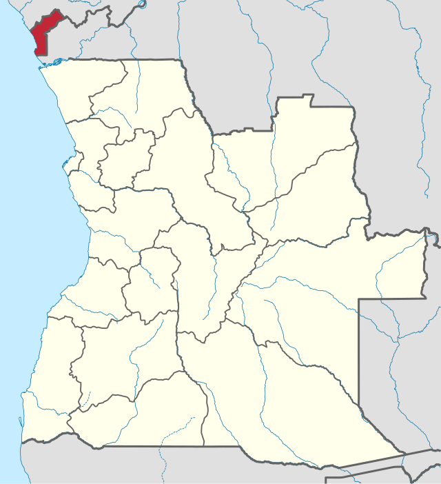
Central-Eastern Angola
- Ethnic group: Lunda-Tchokwé people
- Proposed state: Democratic Republic of Lunda-Tchokwé
- Government-in-exile: Partido Democrático da Defesa do Estado Lunda-Tchokwé,[8][9]
- Political party: Partido Democrático da Defesa do Estado Lunda-Tchokwé[10]
- Advocacy groups: Mulher Unida da Lunda-Tchokwé, Pioneiros Unidos da Lunda-Tchokwé, Juventude Unida da Lunda-Tchokwé, Manifesto Jurídico Sociológico do Povo Lunda-Tchokwé[11]
- Ethnic group: Bakongo
- Proposed state: Republic of Cabinda[12]
- Government-in-exile: Frente para a Libertação do Enclave de Cabinda (FLEC) (member of the Unrepresented Nations and Peoples Organization)
- Political party: Frente para a Libertação do Enclave de Cabinda (FLEC),
 Liberation Front of the State of Cabinda
 - Militant organization: Forças Armadas de Cabinda (FAC)
- Status: Ongoing low-intensity war
![]() Cabinda is a charter member of the Organization of Emerging African States[6]
Cabinda is a charter member of the Organization of Emerging African States[6]
Botswana

Cameroon
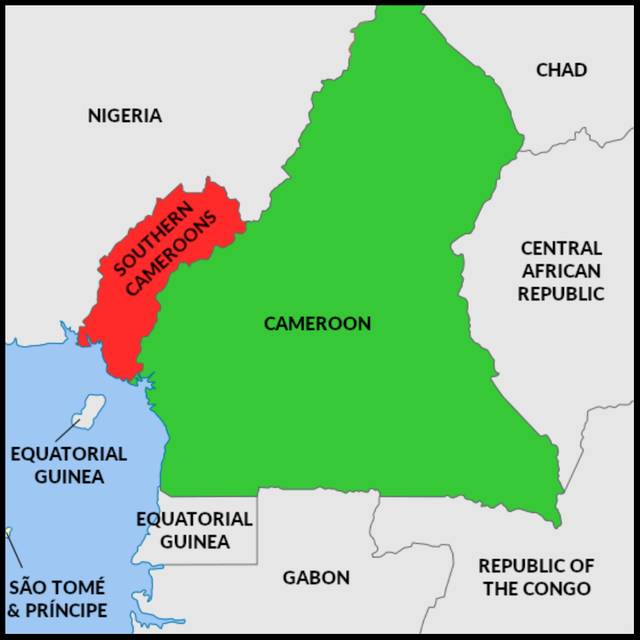
- Ethnic group: Anglophones of the former Southern Cameroons, consisting of over 80 ethnic groups
- Population: ~4 million people
- Proposed state: Federal Republic of Ambazonia[16]
- Advocacy group: Interim Government of Ambazonia, Ambazonia Governing Council and others[17]
- Militant groups: Ambazonia Self-Defence Council, Ambazonia Defence Forces, SOCADEF, other smaller militias
- Status: Ongoing civil war
![]() Ambazonia is a charter member of the Organization of Emerging African States[6]
Ambazonia is a charter member of the Organization of Emerging African States[6]

- People: Oron
- Population: 150,000–300,000 people (subject of dispute)
- Proposed state: Democratic Republic of Bakassi[18]
- Militant groups: Bakassi Movement for Self-Determination
- Status: Active insurgency until 2009, isolated incidents until 2015
Central African Republic
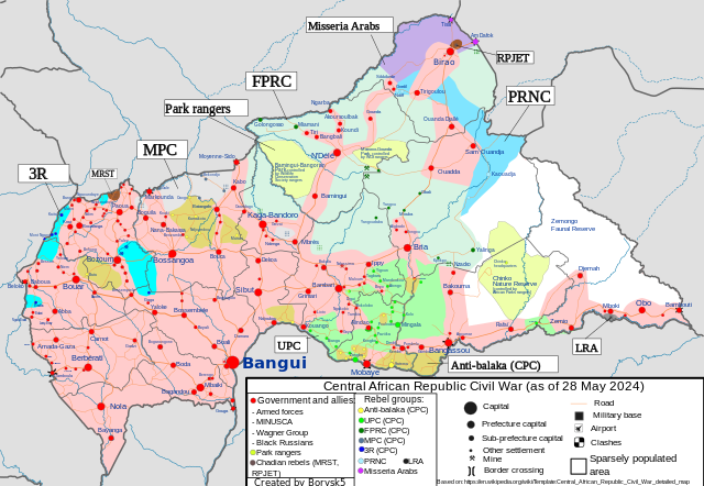
Territories under control of FPRC around 2024

![]() Dar El Kuti (Republic of Logone)
Dar El Kuti (Republic of Logone)
- Ethnic group: Muslims in the Central African Republic
- Proposed state: Dar al-Kuti[19]
- Advocacy group and militant organization: Séléka[20]
- Status: Ongoing civil war, effectively a proto-state
Dar El Kuti is a self-proclaimed state supported by the Popular Front for the Rebirth of Central African Republic (FPRC), a Muslim rebel movement in the Central African Republic.[21]
Comoros

- Ethnic group: people of Anjouan
- Proposed state:
 Anjouan
 - Political party: Mouvement Populaire Anjouanais
- Proposed state:
- Ethnic group: Mohélians
- Proposed state:
 Mohéli
- Proposed state:
Republic of the Congo
![]() South Congo (Brazzaville)[citation needed]
South Congo (Brazzaville)[citation needed]
- Ethnic group: South Congolese
- Advocacy group: Provisional Assembly and governance of the State of South Congo[citation needed]
- Proposed state:
 State of South Congo[24][25]
Democratic Republic of the Congo

- Advocacy group: Bundu dia Kongo
- Proposed state: Kingdom of Kongo[26]
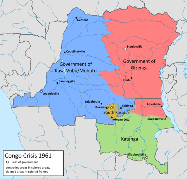
- Political parties: Union of Independent Federalists and Republicans
- Militant organizations: Mai Mai Kata Katanga
 Katanga is a charter member of the Organization of Emerging African States[6]
Eritrea

- Ethnic group: Afar people, Saho people
- Proposed autonomous area:
 Dankalia or unification with
  Ethiopia
 - Advocacy groups:
 Red Sea Afar Democratic Organisation,
  Democratic Movement for the Liberation of the Eritrean Kunama,
  Saho People's Democratic Movement[27][28][29][30]
- Proposed autonomous area:
Equatorial Guinea
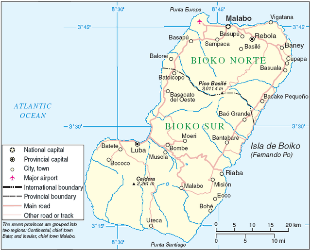
- Ethnic group: Bubi
- Proposed state: Bioko Island
- Advocacy group: Movement for the Self-Determination of Bioko Island

- Ethnic group: Portuguese Africans
- Proposed state: Republic of Annobón[31]
- Advocacy group:
 Free Annobón[32][33]
Ethiopia
Summarize
Perspective


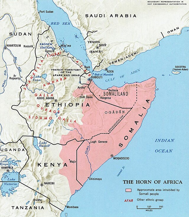
- Proposed state: Ogadenia (member of the Unrepresented Nations and Peoples Organization) or unification with
 Somalia
- Political party: Ogaden National Liberation Front

- Proposed state or autonomous area:
 Oromia (member of the Unrepresented Nations and Peoples Organization)
- Militant organizations:
 Oromo Liberation Front,
  Islamic Front for the Liberation of Oromia
 - Advocacy group: Qeerroo
- Militant organizations:
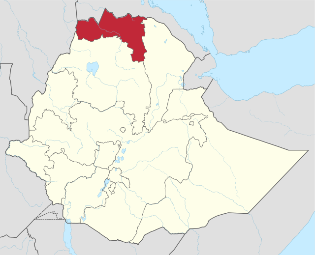
- Proposed state or autonomous area: Tigray[34]
- Political party: Tigray Independence Party[35]
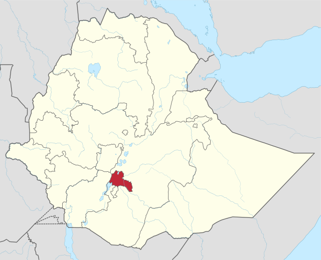
- Proposed: Self-determination and/or autonomy for the Sidama people
- Militant organization:
 Sidama National Liberation Front[36]
- Militant organization:

- ethnic group: Amhara people
- proposed: self determination and/or autonomy for
 Amhara
 - political party: National Movement of Amhara
- status: Ongoing
- proposed: self determination and/or autonomy for
- ethnic group: Afar people
- proposed: independence for the
 Afar Region
 - political party: Afar Liberation Front (former militant organization)
- militant organization: Afar Revolutionary Democratic Unity Front
- proposed: independence for the
- Ethnic group: Welayta people
- Proposed: autonomy for the Wolayita Zone
- Political party: Wolaita People's Liberation Movement
France
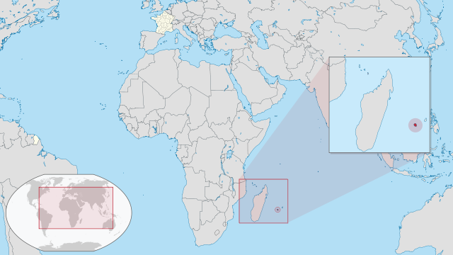
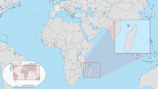
- Political party:
 Lorganizasion Popilèr po Libèr nout Péi (Lplp) – Popular Front for National Liberation: composed of Nasion Rénioné, Mar, Drapo rouz, Patriot rénioné and Mir.
 - Political party: Communist Party of Réunion
- Proposed state:
 Republic of Zabon
- Political party:
![]() Mayotte continues to have autonomist and separatist movements despite the island having voted to become France's 101st department in 2011.[42]
Mayotte continues to have autonomist and separatist movements despite the island having voted to become France's 101st department in 2011.[42]
Ghana

- Proposed state: Western Togoland
- Militant organizations: Western Togoland Restoration Front (member of UNPO)
- Proposed state: Western Togoland
Kenya

- Proposed state: Coast Province, Mombasa Republic
- Political party: Mombasa Republican Council[43][44]
- Status: Active[45]
 Mombasa Republic is a charter member of the Organization of Emerging African States[6]
Rift Valley, Western Province, Nyanza
- Proposed State or autonomous region: People's Republic of Kenya
- Political Party:
 Azimio la Umoja[46][47][48][49]
- Political Party:
Libya

- Ethnic group: Arabs,
- Proposed autonomous region or state:
 Cyrenaica[51]
 - Political party: Cyrenaica Transitional Council
- Proposed autonomous region or state:
Malawi
Nyika
Mali
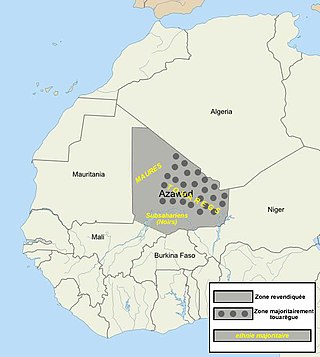
Dark grey dots indicate regions with a Tuareg majority.
- Ethnic group: Tuareg
- Proposed state or autonomous area:
 Azawad
 - Political party: Coordination of Azawad Movements, which includes MNLA
- Militant organisations: National Movement for the Liberation of Azawad
 Azawad is a charter member of the Organization of Emerging African States[6]
- Proposed state or autonomous area:
- Ethnic group: Fula
- Proposed state: Massina Empire
- Militant organizations: Katiba Macina[57][58][59]
Mauritius

- Ethnic group: Rodriguan
- Proposed greater autonomous area or state:
 Rodrigues
 - Political party: Rodrigues People's Organisation[60][61]
- Proposed greater autonomous area or state:
Morocco

- Ethnic group: Riffian Berbers
- Proposed state: Republic of the Rif
- Political organization: Riffian National Party[62][63][64]
Started in Morocco during the 1920s,[65][66] and was revitalized in 2013.[67] The Rif Independence Movement is a charter member of the Organization of Emerging African States.[67]
Namibia

- Ethnic group: Masubia, Nzanza, Mbowe, Makalahari, MaYeyi, Mampukushu, Makwengari, Mambunda, Matotela, Batoka, Mafwe, Barotse, Leya, Nanzwa, Lujana, Dombe
- Advocacy group: Movement for the Survival of the River Races of Zambesia
- Militant organization:
 Caprivi Liberation Army[68]
 - Political party: Caprivi National African Union,
 United Democratic Party
 - Proposed state:
 Zambesia[13][14] or Caprivi Strip[69] or
  Barotseland
- Ethnic group: Baster
- Proposed autonomous area:
 Rehoboth area[70]
 - Political party: The United People`s Movement (UPM)[71] Rehoboth Basters (Member of the UNPO)[72]
- Proposed autonomous area:
Nigeria
Summarize
Perspective

- Ethnic group: Igbo, Anioma, Igede, Igala, Idoma, Ijaw, Kalabari, Ibibio, and Ogoni.
- Proposed state:
 Republic of Biafra (defunct)
 - Separatist movements: The Indigenous People of Biafra, Biafra Zionist Movement, Movement for the Actualization of the Sovereign State of Biafra
- Militant organization: Eastern Security Network
- Government in exile: Biafran Government in exile[73]
 Biafra is a charter member of the Organization of Emerging African States[6]
- Proposed state:
- Ethnic group:
 Yorùbá ethnic groups in Ekiti, Lagos, Ogun, Ondo, Oyo, Osun, Kwara, Òkun in Kogi states in Nigeria, Itsekiris in Delta state and Akoko in Edo state.
- Proposed state:
 Republic of Oduduwa
 - Member of the Unrepresented Nations and Peoples Organization[74]
- Civic organizations: Ilana Omo Oodua, Nigerian Indigenous Nationalities Alliance for Self-Determination(NINAS)
- Movement leaders: Professor Stephen Adebanji Akintoye, Sunday Igboho
- O'odua Grand Alliance for Independence & Oodua People's Congress Ogafi.org [75]
- Status: Constitutional Force Majeure
- Proposed state:

- Ethnic group: Urhobo, Isoko, Itsekiri, Ijaw, Ukwuani, Edo, Esan, Ogoni, Kalabari and many more.
- Proposed: Autonomous regionalism:
 Niger Delta Republic[77] was declared in February 1965 by Isaac Adaka Boro,[78] but failed to be established and remains an inspiration if not an aspiration.[79]
 - Movement: Movement for the Emancipation of the Niger Delta (MEND) formed in 2006 for the self-determination of the people of the Niger Delta[80]
- Militant groups: Niger Delta Avengers,[81] Niger Delta Greenland Justice Mandate, Niger Delta Vigilante, Niger Delta People's Volunteer Force (NDPVF),
- Status: Ongoing war
- Proposed: Autonomous regionalism:

- Ethnic group: Hausa people, Kanuri people
- Proposed State or Autonomous Area:
 Arewa Republic
 - Political organisations Arewa Consultative Forum
- Proposed State or Autonomous Area:
- Ethnic group: Ogoni people
- Proposed autonomous region:
 Ogoniland[83]
 - Advocacy group: Movement for the Survival of the Ogoni People
- Proposed autonomous region:
- ethnic group: Edo people, Yoruba People, Igbo people
- proposed: re establishment of the
 Kingdom of Benin
 - political party: United Kingdom of Great Benin[84]
- proposed: re establishment of the
Portugal
- Ethnic group: Madeiran
- Proposed: Greater autonomy for
 Madeira
 - Political party: Together for the People
- Proposed: Greater autonomy for
Senegal

- Ethnic group: Diola
- Proposed state:
 Republic of Casamance
 - Militant organization: Movement of Democratic Forces of Casamance[85]
- Proposed state:
Somalia
- Ethnic group: Somali, primarily the Isaaq clan.[86]
- De facto state:
 Somaliland
 - Political organisations: Government of Somaliland
- Militant organisation: Somaliland Armed Forces
- De facto state:
- Ethnic group: Somali
- Ethnic group: Somali, primarily the Gadabuursi clan.
- Proposed state:
 Awdalland
 - Political party: Awdal State Movement
- Proposed state:
Spain
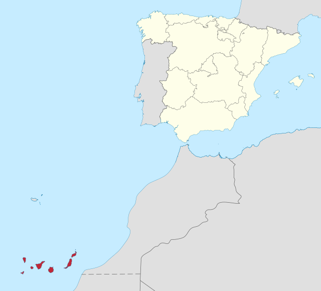
- Secessionist movement
- People: Canarians
- Proposed state:
 Republic of the Canary Islands
- Political parties (autonomist): Coalición Canaria, Partido Nacionalista Canario, Centro Canario Nacionalista, Nueva Canarias
- Political parties (secessionist): FREPIC-AWAÑAK, Tanekra, Alternativa Nacionalista Canaria, Alternativa Popular Canaria, Unidad del Pueblo, National Congress of the Canaries
- Trade union: Intersindical Canaria
- Youth movement: Azarug
- Proposed state:
![]() Canary Islands is a charter member of the Organization of Emerging African States[6]
Canary Islands is a charter member of the Organization of Emerging African States[6]
South Africa
Summarize
Perspective

- Proposed state or autonomous area:
 Cape Republic[93]
- Ethnic groups: Cape Coloureds, Afrikaners, Khoisan, Cape Malays, Bantu peoples of South Africa (Primarily Xhosa)
- Political parties: Freedom Front Plus[94] Referendum Party Cape Independence Party[95]
- Advocacy groups: CapeXit[96] Cape Independence Advocacy Group (CIAG),[93]
- Proposed state or autonomous area:
 Sovereign State of Good Hope[97]
- Ethnic groups: Cape Coloureds, Khoisan, Cape Malays, Griqua people
- Advocacy Groups:
 Goringhaicona Khoikhoin Indigenous Traditional Council,[a][6] First Indigenous Nation of South Africa (FINSA)
 - Status: Unrecognized
- Ethnic group: Afrikaners
- Proposed state or autonomous area: Volkstaat[98]
- Political Party: Freedom Front Plus (in parliament and member of the Unrepresented Nations and Peoples Organization).[99] Outside parliament: Afrikaner Weerstandsbeweging, National Conservative Party of South Africa, Boerestaat Party, Herstigte Nasionale Party, Afrikaner Self-determination Party.
- Advocacy group: Orania Movement
- Movement: Boere-Vryheidsbeweging
- Status: Accord on Afrikaner self-determination
- Autonomous area: Zulu Kingdom
- Political Party: Inkatha Freedom Party, Abantu Batho Congress
- Status: Autonomy for traditional African communities and their leaders
- Ethnic group: Vhavenda
- Proposed state:
 Venda
Venda - Political Party: Dabalorivhuwa Patriotic Front
- Proposed state:
South Sudan
- Ethnic group: Nuer People
Sudan

- Ethnic group: Fur, Arabs, Zaghawa, Masalit, Tama
- Proposed autonomous area:
 Darfur or proposed unification with Chad[103][104]
 - Militant organization: Darfur Liberation Front
- Proposed autonomous area:
- Ethnic group: Beja
- Proposed autonomous area or state:
 Beja state[105][106][104]
 - Political groups: Beja Congress[106]
- Proposed autonomous area or state:
Tanzania
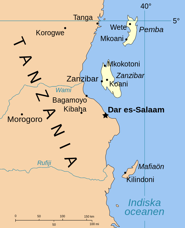
- Ethnic group: Arabs, Shirazi
- Proposed state:
 Zanzibar
 - Political party: Civic United Front (member of Unrepresented Nations and Peoples Organization), Uamsho[107]
- Proposed state:
Uganda
- Proposed: autonomy within Uganda
United Kingdom
![]() British Indian Ocean Territory
British Indian Ocean Territory
- Ethnic group: Chagossian People
Zambia
Zimbabwe

- Ethnic group: Matabele
See also
Notes
- Khoi-San is a charter member of the Organization of Emerging African States
References
Wikiwand - on
Seamless Wikipedia browsing. On steroids.