Nieuwolda
Village in Groningen, Netherlands From Wikipedia, the free encyclopedia
Nieuwolda is a village in the Dutch province of Groningen. It is located in the municipality of Oldambt, about 9 km southeast of Delfzijl.
Nieuwolda | |
|---|---|
 Protestant Church in 2007 | |
 Nieuwolda Location of Nieuwolda in the province of Groningen  Nieuwolda Nieuwolda (Netherlands) | |
| Coordinates: 53°14′41″N 6°58′33″E | |
| Country | Netherlands |
| Province | Groningen |
| Municipality | Oldambt |
| Area | |
• Total | 28.97 km2 (11.19 sq mi) |
| Elevation | −0.3 m (−1.0 ft) |
| Population (2021)[1] | |
• Total | 1,350 |
| • Density | 47/km2 (120/sq mi) |
| Postal code | 9944[1] |
| Dialing code | 0596 |
Nieuwolda was a separate municipality until 1990, when it was merged with Scheemda.[3]
History
The village was first mentioned in 1711 as Midde en Nieuwolda, and means "new woods". Nieuw (new) was added to distinguish between Midwolda.[4] Nieuwolda is a road village which developed as a satellite of Midwolda after the Dollart dike was constructed in 1545.[5]
The Dutch Reformed church was built in 1718 and a tower was added in 1765.[5] The weather vane is a mermaid as a reference to the reclaimed land from the Dollart.[6] The pumping station De Hoogte was constructed in 1892 and was powered by a steam engine. In 1920, it was converted to an electric engine. It became obsolete in 1976. It has been restored and in use as a museum.[6]
Nieuwolda was home to 1,315 people in 1840.[6] It was a separate municipality until 1990, when it was merged with Scheemda. In 2010, it became part of Oldambt.[6]
Gallery
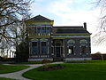 Farm in Nieuwolda
 Pumping station De Hoogte
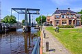 Draw bridge in Nieuwolda
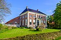 Farm in Nieuwolda


.jpg)

References
External links
Wikiwand - on
Seamless Wikipedia browsing. On steroids.