Top Qs
Timeline
Chat
Perspective
Nicholson River (Victoria)
River in Victoria, Australia From Wikipedia, the free encyclopedia

Remove ads
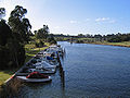
The Nicholson River is a perennial river of the Mitchell River catchment, located in the East Gippsland region of the Australian state of Victoria.[9]


Remove ads
Course and features
The Nicholson River rises below the Angora Range in the lower reaches of the Victorian Alps within the Great Dividing Range, near the small settlement of Marthavale, west of Ensay.[10] The river flows generally southeast passing through the small town of Nicholson before entering Lake King, one of the main lakes in the extensive Gippsland Lakes system.[9] Within the lake, the Nicholson River forms its confluence with the Mitchell River, which joins with the Tambo River; with the Mitchell River draining into Bass Strait southwest of Lakes Entrance, in the Shire of East Gippsland. The river descends 440 metres (1,440 ft) over its 83-kilometre (52 mi) course.[8][11]
The river is impounded by the Nicholson River Dam, that forms a water reservoir used for the supply of town water to Lakes Entrance, until 1995.[12]
In its lower reaches, the river is traversed by the Great Alpine Road, the Princes Highway, and the East Gippsland Rail Trail,[8] a shared purpose rail trail that was formerly the part of the Orbost railway line.
Remove ads
Etymology
There are a number of Australian Aboriginal names for the river including: from the Brabralung language Yowen-burrun[2] and Dart'yung,[3] both meaning "root of water plant";[4] Geremoot, with no clearly defined meaning;[5] and in the Tatungalung language, Ngarrak walang, meaning "back-stone".[6]
The current name of the river was given by the early colonial explorer and pastoralist, Angus McMillan, who named the river in 1839 in honour of Charles Nicholson, who represented the Port Phillip District on the NSW Legislative Council and was later Colonial Secretary.[1]
Remove ads
See also
Gallery
 Looking north to the rail trail trestle bridge across the river at Nicholson

References
External links
Wikiwand - on
Seamless Wikipedia browsing. On steroids.
Remove ads