Municipality of Lorne
Rural municipality in Manitoba, Canada From Wikipedia, the free encyclopedia
Rural municipality in Manitoba, Canada From Wikipedia, the free encyclopedia
The Municipality of Lorne (French: Municipalité de Lorne) is a rural municipality (RM) in the Canadian province of Manitoba.
Lorne | |
|---|---|
| Municipality of Lorne | |
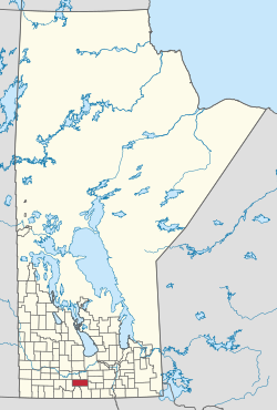
 Location of the RM of Lorne in Manitoba | |
| Coordinates: 49°26′37″N 98°44′58″W | |
| Country | Canada |
| Province | Manitoba |
| Region | Central Plains and Pembina Valley |
| Division | Pilot Mound Census Division |
| Incorporated (amalgamated) | January 1, 2015[1] |
| Time zone | UTC-6 (CST) |
| • Summer (DST) | UTC-5 (CDT) |
The RM was created on January 1, 2015 via the amalgamation of the RM of Lorne and the villages of Notre-Dame-de-Lourdes and Somerset.[1] It was formed as a requirement of The Municipal Amalgamations Act, which required that municipalities with a population less than 1,000 amalgamate with one or more neighbouring municipalities by 2015.[2] The Government of Manitoba initiated these amalgamations in order for municipalities to meet the 1997 minimum population requirement of 1,000 to incorporate a municipality.[3]
In the 2021 Census of Population conducted by Statistics Canada, Lorne had a population of 2,904 living in 1,103 of its 1,199 total private dwellings, a change of -4.5% from its 2016 population of 3,041. With a land area of 923.03 km2 (356.38 sq mi), it had a population density of 3.1/km2 (8.1/sq mi) in 2021.[4]
Seamless Wikipedia browsing. On steroids.
Every time you click a link to Wikipedia, Wiktionary or Wikiquote in your browser's search results, it will show the modern Wikiwand interface.
Wikiwand extension is a five stars, simple, with minimum permission required to keep your browsing private, safe and transparent.