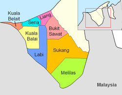
Mukim Liang
Mukim of Brunei From Wikipedia, the free encyclopedia
Mukim Liang is a mukim in Belait District, Brunei.[3] The population was 14,301 in 2016.[4]
The mukim is located in the north of the district, bordering the South China Sea to the north, Mukim Telisai in Tutong District to the north-east, Mukim Bukit Sawat to the south-east, Mukim Labi to the south and Mukim Seria to the west.[5]
As of 2016 census,[4] the population was 14,301 with 51.4% males and 48.6% females. The mukim had 2,607 households occupying 2,602 dwellings. Among the population, 32.3% lived in urban areas, while the remainder of 67.7% lived in rural areas.
As of 2021, the mukim comprised the following villages:
Settlements[2] | Population (2021)[2] | Ketua kampung (2024)[1][6] |
---|---|---|
Kampong Sungai Tali | 1,051 | Haji Khairdon bin Haji Dahlan |
Kampong Sungai Taring | 857 | |
Kampong Sungai Bakong | 1,642 | Taib bin Haji Salleh |
Kampong Sungai Kuru | 495 | |
Kampong Lumut | 171 | |
Kampong Lumut Camp | 864 | — |
RPN Kampong Lumut Area 1 | 2,035 | Saini bin Ismail |
RPN Kampong Lumut Area 2 | 5,605 | Salleh bin Haji Bujang |
Kampong Lumut Tersusun | 1,205 | Taib bin Haji Salleh |
Kampong Sungai Kang | 56 | |
Kampong Sungai Lalit | 397 | |
Kampong Agis-Agis | 217 | |
Kampong Perumpong | 427 | — |
Kampong Sungai Liang | 641 | Mohammad Haszrin bin Bagol |
Kampong Tunggulian | 656 | — |
Kampong Lilas | 148 | |
Kampong Sungai Gana | 160 | |
Kampong Keluyoh | 186 |
Seamless Wikipedia browsing. On steroids.
Every time you click a link to Wikipedia, Wiktionary or Wikiquote in your browser's search results, it will show the modern Wikiwand interface.
Wikiwand extension is a five stars, simple, with minimum permission required to keep your browsing private, safe and transparent.