Top Qs
Timeline
Chat
Perspective
Mukim Amo
Mukim of Brunei From Wikipedia, the free encyclopedia
Remove ads
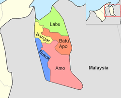
Mukim Amo is a mukim in Temburong District, Brunei. It has an area of 542 square kilometres (209 sq mi);[2] the population was 1,657 in 2021.[4]
Remove ads
Etymology
The mukim is named after Kampong Amo, one of the villages it encompasses.[citation needed]
Geography
The mukim is located in the eastern part of the district,[2] bordering Mukim Batu Apoi to the north-east, Mukim Bokok to the west and Mukim Bangar to north-west, as well as the Malaysian state of Sarawak to the east and south.
Hills
- Pagon Hill is the highest hill in the country with a height of 1,850 metres (6,070 ft).[5]
- Retak Hill has a height of 1,618 metres (5,308 ft).[6]
- Tudal Hill has a height of 1,181 metres (3,875 ft).[7]
Remove ads
Demography
As of 2021 census,[4] the population was 1,657 with 53.6% males and 46.4% females. The mukim had 364 households occupying 320 dwellings. The entire population lived in rural areas.
Administration
As of 2021, the mukim comprised the following census of villages:
Remove ads
Infrastructure
Schools
The government primary schools in the mukim include:
- Amo Primary School
- Selangan Primary School
Meanwhile, the government schools for the country's Islamic religious primary education include:
- Amo Religious School
- Selangan Religious School
Mosques
Remove ads
Notes
- Also administered as three villages i.e. Kampong Amo 'A', 'B' and 'C'
- Not to be confused with the village of the same name in Mukim Rambai, Tutong District
- Not to be confused with the villages of the same name in Mukim Kianggeh and Mukim Pengkalan Batu in Brunei-Muara District
- Kampong Sibut and Kampong Sumbiling are administered under one village head since 1 March 2020.[9]
- Kampong Sumbiling Baru and Kampong Sumbiling Lama are collectively known as Kampong Sumbiling.
Remove ads
References
External links
Wikiwand - on
Seamless Wikipedia browsing. On steroids.
Remove ads


