Top Qs
Timeline
Chat
Perspective
Mount Tasman
Mountain in New Zealand From Wikipedia, the free encyclopedia

Remove ads
Mount Tasman (Te Horokōau in Māori)[1][2] is New Zealand's second-highest mountain, rising to a height of 3,497 metres (11,473 ft). It is located in the Southern Alps of the South Island, four kilometres to the north of its larger neighbour, Aoraki / Mount Cook. Unlike Aoraki / Mount Cook, Mount Tasman sits on the South Island's Main Divide, on the border between Aoraki / Mount Cook National Park and Westland Tai Poutini National Park. It is the highest point in Westland District.[citation needed]
.png)
The first ascent of Mount Tasman was in 1895 by Edward FitzGerald and his guide Matthias Zurbriggen.[3]
The Māori name (horo: to swallow; koau: shag or Phalacrocorax varius) is believed to refer to the swelling in the neck of a shag when it is swallowing a fish.[4]
Remove ads
Aoraki / Mount Cook National Park
Mount Tasman is located in Aoraki / Mount Cook National Park in the Canterbury Region, which was established in 1953 and along with Westland Tai Poutini National Park, Mount Aspiring National Park and Fiordland National Park forms one of the UNESCO World Heritage Sites.[citation needed]
Gallery
 Mt Tasman north shoulder view south to summit, 21 March 1983
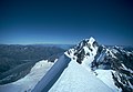 Aoraki peak from Mt Tasman summit NZ Mon 21 March 1983 wideangle
 Mt Tasman north shoulder view west to Tasman Sea NZ Mon 21 March 1983
 Mt Tasman summit NZ view down the east face to Grand Plateau & Tasman glacier Mon 21 March 1983
 Mt Tasman peak looking SW from Mt Haidinger summit, 19 March 1983
 Mt Haast, Mt Lendenfeld, Mt Tasman and Torres Peak NZ helicopter view from NW, Nov 28 2008
 Mt Tasman helicopter view from SE above Grand Plateau, Nov 28 2008
 Mt Tasman viewed from north at helicopter landing on Fox nevé, Nov 28 2008


Remove ads
See also
References
Wikiwand - on
Seamless Wikipedia browsing. On steroids.
Remove ads