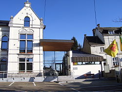
Mont-Saint-Guibert
Municipality in French Community, Belgium From Wikipedia, the free encyclopedia
Municipality in French Community, Belgium From Wikipedia, the free encyclopedia
Mont-Saint-Guibert (French pronunciation: [mɔ̃ sɛ̃ ɡibɛʁ]; Walloon: Mont-Sint-Wubert) is a municipality of Wallonia located in the Belgian province of Walloon Brabant. On January 1, 2012, Mont-Saint-Guibert had a total population of 7000. The total area is 18.63 km2 (7.19 sq mi) which gives a population density of 344 inhabitants per square kilometre (890/sq mi).
Mont-Saint-Guibert | |
|---|---|
 Mont-Saint-Guibert town hall | |
| Coordinates: 50°38′N 04°37′E | |
| Country | |
| Community | French Community |
| Region | Wallonia |
| Province | Walloon Brabant |
| Arrondissement | Nivelles |
| Government | |
| • Mayor | Julien Breuer |
| • Governing party/ies | Mont-Saint-Guibert Cohésion |
| Area | |
| • Total | 18.72 km2 (7.23 sq mi) |
| Population (2018-01-01)[1] | |
| • Total | 7,562 |
| • Density | 400/km2 (1,000/sq mi) |
| Postal codes | 1435 |
| NIS code | 25068 |
| Area codes | 010 |
| Website | www.mont-saint-guibert.be |
In addition to Mont-Saint-Guibert itself, the municipality includes the villages of Corbais and Hévillers.
Before the owners of Stella Artois brewery bought the business, Leffe beer was brewed in the village along with Vieux Temps. The brewery was subsequently closed and production was moved to Leuven in the Flemish part of the country.
The commune is now fast developing with the arrival of many commuters who have moved from the capital city of Brussels. They are served by a local station and the nearby E411 Brussels to Luxembourg highway.
Seamless Wikipedia browsing. On steroids.
Every time you click a link to Wikipedia, Wiktionary or Wikiquote in your browser's search results, it will show the modern Wikiwand interface.
Wikiwand extension is a five stars, simple, with minimum permission required to keep your browsing private, safe and transparent.