Marrowbone, Cumberland County, Kentucky
Census-designated place in Kentucky, United States From Wikipedia, the free encyclopedia
Census-designated place in Kentucky, United States From Wikipedia, the free encyclopedia
Marrowbone is a census-designated place in Cumberland County, Kentucky, United States. As of the 2010 census it had a population of 217.[2] It has a post office, with the ZIP code of 42759.[3]
Marrowbone, Kentucky | |
|---|---|
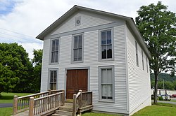
 Modern Woodmen lodge building on Kentucky Route 90 | |
| Coordinates: 36°49′39″N 85°30′24″W | |
| Country | United States |
| State | Kentucky |
| County | Cumberland |
| Area | |
| • Total | 1.29 sq mi (3.34 km2) |
| • Land | 1.27 sq mi (3.30 km2) |
| • Water | 0.01 sq mi (0.04 km2) |
| Elevation | 643 ft (196 m) |
| Population (2020) | |
| • Total | 147 |
| • Density | 115.38/sq mi (44.54/km2) |
| Time zone | UTC-6 (Central (CST)) |
| • Summer (DST) | UTC-5 (CDT) |
| ZIP codes | 42759 |
| FIPS code | 21-50124 |
| GNIS feature ID | 497558 |
The Marrowbone Historic District, which includes three properties, is listed on the National Register of Historic Places.
It lies along Kentucky Route 90 west of the city of Burkesville, the county seat of Cumberland County.[4] Its elevation is 643 feet (196 m), and it is located at about (36.8288889, -85.5030556).[5]
Seamless Wikipedia browsing. On steroids.
Every time you click a link to Wikipedia, Wiktionary or Wikiquote in your browser's search results, it will show the modern Wikiwand interface.
Wikiwand extension is a five stars, simple, with minimum permission required to keep your browsing private, safe and transparent.