Lospalos
City in Lautém, East Timor From Wikipedia, the free encyclopedia
City in Lautém, East Timor From Wikipedia, the free encyclopedia
Lospalos — sometimes erroneously written as Los Palos, assuming a nonexistent Spanish etymology — is a city in East Timor, 248 kilometres (154 mi) to the east of Dili, the national capital. Lospalos has a population of 17,186 (2006) and is the capital of Lautém Municipality and the Lospalos Administrative Post. The subdistrict has a population of 25,417 (2004).
You can help expand this article with text translated from the corresponding article in German. (November 2010) Click [show] for important translation instructions.
|
Lospalos | |
|---|---|
City | |
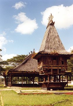
 Sacred house in Lospalos | |
| Coordinates: 8°31′20″S 126°59′51″E | |
| Country | |
| Municipality | Lautém |
| Administrative post | Lospalos |
| Area | |
| • Total | 623.93 km2 (240.90 sq mi) |
| Elevation | 346 m (1,135 ft) |
| Population (2015 census) | |
| • Total | 12,665 |
| • Density | 20/km2 (53/sq mi) |
| Time zone | UTC+09:00 (TLT) |
| Climate | Aw |

Internationally, "Lospalos" is mistakenly spelled as Los Palos, suggesting a Spanish origin of the name. In fact, it is derived from Lohoasupala, the name in Fataluku, the local Papuan language, although nowadays Fataluku speakers use the name Lospala. The preferred spelling in English, as well as Tetum and Portuguese, the official languages of East Timor, is Lospalos.
Lospalos is the birth city of the Timorese combatant the Former Regional Commander of Ponta Leste in 1975-1977, José dos Santos, born on September 20, 1945, in Nanakuru, Souro Village.
Lospalos is the birth city of the co-founder and president of the party APODETI, Frederico Almeida Santos Costa.
Lospalos has a tropical savanna climate (Köppen Aw) with a dry season from August to October and a wet season covering the remaining nine months.
| Climate data for Lospalos | |||||||||||||
|---|---|---|---|---|---|---|---|---|---|---|---|---|---|
| Month | Jan | Feb | Mar | Apr | May | Jun | Jul | Aug | Sep | Oct | Nov | Dec | Year |
| Mean daily maximum °C (°F) | 29.2 (84.6) |
29.0 (84.2) |
29.4 (84.9) |
29.3 (84.7) |
28.3 (82.9) |
27.5 (81.5) |
27.3 (81.1) |
27.9 (82.2) |
29.5 (85.1) |
30.9 (87.6) |
31.2 (88.2) |
30.4 (86.7) |
29.2 (84.5) |
| Daily mean °C (°F) | 25.8 (78.4) |
25.6 (78.1) |
25.6 (78.1) |
25.3 (77.5) |
24.4 (75.9) |
23.6 (74.5) |
23.1 (73.6) |
23.2 (73.8) |
24.3 (75.7) |
25.4 (77.7) |
26.4 (79.5) |
26.3 (79.3) |
24.9 (76.8) |
| Mean daily minimum °C (°F) | 22.5 (72.5) |
22.2 (72.0) |
21.8 (71.2) |
21.4 (70.5) |
20.6 (69.1) |
19.7 (67.5) |
19.0 (66.2) |
18.6 (65.5) |
19.1 (66.4) |
19.9 (67.8) |
21.7 (71.1) |
22.3 (72.1) |
20.7 (69.3) |
| Average rainfall mm (inches) | 216 (8.5) |
214 (8.4) |
220 (8.7) |
234 (9.2) |
283 (11.1) |
186 (7.3) |
89 (3.5) |
21 (0.8) |
7 (0.3) |
19 (0.7) |
81 (3.2) |
209 (8.2) |
1,779 (69.9) |
| Source: Climate-Data.org[1] | |||||||||||||
Seamless Wikipedia browsing. On steroids.
Every time you click a link to Wikipedia, Wiktionary or Wikiquote in your browser's search results, it will show the modern Wikiwand interface.
Wikiwand extension is a five stars, simple, with minimum permission required to keep your browsing private, safe and transparent.