Lithoijen
Village in North Brabant, Netherlands From Wikipedia, the free encyclopedia

Lithoijen is a village in the Dutch province of North Brabant. It is located in the municipality of Oss, about 5 km northwest of the city of Oss.
Lithoijen | |
|---|---|
Village | |
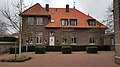
 Former town hall | |
 Lithoijen Location in the province of North Brabant in the Netherlands  Lithoijen Lithoijen (Netherlands) | |
| Coordinates: 51°48′9″N 5°27′48″E | |
| Country | Netherlands |
| Province | North Brabant |
| Municipality | Oss |
| Area | |
• Total | 9.05 km2 (3.49 sq mi) |
| Elevation | 5.1 m (16.7 ft) |
| Population (2021)[1] | |
• Total | 840 |
| • Density | 93/km2 (240/sq mi) |
| Time zone | UTC+1 (CET) |
| • Summer (DST) | UTC+2 (CEST) |
| Postal code | 5396[1] |
| Dialing code | 0412 |
History
The village was first mentioned between 987 and 996 as Littam, and means "land on a river near Lith".[3]
The Catholic St. Remigus Church was built between 1900 and 1901. The tower has a slender needle spire. The former Franciscan monastery was built around 1895 in Gothic Revival style. Until 1950, it housed a girls boarding school.[4] In 1833, a fort was built in Lithoijen, because an attack was feared during the Belgian Revolution. It was never used, and decommissioned in 1886. Only elevations in the landscape reveal its presence.[5]
Lithoijen was home to 735 people in 1840.[6] Lithoijen was a separate municipality until 1939, when it became part of Lith.[7] In 2011, it became part of the municipality of Oss.[6]
Gallery
 Building in Lithoijen
 St Remigus Church
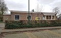 School in Lithoijen
 Marina


References
Wikiwand - on
Seamless Wikipedia browsing. On steroids.