Top Qs
Timeline
Chat
Perspective
List of airports in the Falkland Islands
From Wikipedia, the free encyclopedia
Remove ads
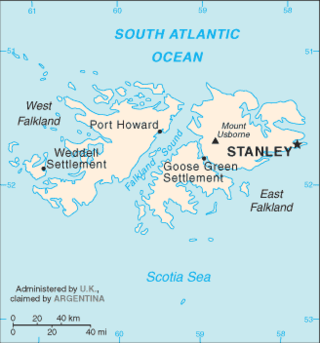
The Falkland Islands are an archipelago in the South Atlantic Ocean, located about 250 nautical miles (460 km; 290 mi) from the coast of mainland South America and 600 nautical miles (1,100 km; 690 mi) from mainland Antarctica. The archipelago, consisting of East Falkland, West Falkland and 776 lesser islands, is a self-governing Overseas Territory of the United Kingdom.[1] The capital, Stanley, is on East Falkland. The islands contain two airports with paved runways, with settlements around the archipelago served by grass airstrips.

Remove ads
Airports
Summarize
Perspective
Other FIGAS airstrips
East Falklands:
- Bleaker Island
- Darwin
- Douglas Station (51°27′36″S 58°36′48″W)
- George Island (52°20′59″S 59°45′35″W)
- Goose Green (51°49′12″S 58°58′54″W)
- Lively Island (51°59′43″S 58°27′40″W)
- North Arm (52°7′25″S 59°22′14″W)
- Port San Carlos (51°30′06″S 59°00′16″W)
- Salvador (51°26′9″S 58°22′37″W)
- Sea Lion Island (52°25′39″S 59°4′42″W)
- Speedwell Island
West Falklands:
- Albemarle
- Beaver Island (51°50′25″S 61°13′59″W)
- Carcass Island (51°15′51″S 60°35′27″W)
- Chartres
- Dunnose Head (51°45′12″S 60°24′59″W)
- Fox Bay (51°56′3″S 60°3′48″W)
- Hill Cove (51°30′18″S 60°8′43″W)
- New Island (51°44′46″S 61°16′54″W)
- Pebble Island (51°18′33″S 59°36′35″W)
- Port Edgar
- Port Howard (51°36′48″S 59°30′59″W)
- Port Stephens (52°5′44″S 60°51′4″W)
- Roy Cove (51°32′23″S 60°21′22″W)
- Saunders Island
- Shallow Harbour (51°45′20″S 60°32′9″W)
- Spring Point (51°49′47″S 60°27′11″W)
- Weddell Island (51°52′33″S 60°54′23″W)
- West Point Island (51°20′44″S 60°41′3″W)
They are in general 500–700 metres (1,600–2,300 ft) long
Remove ads
See also
References
Wikiwand - on
Seamless Wikipedia browsing. On steroids.
Remove ads
