| Building address |
Grid Ref.[note 1]
Geo-coordinates |
Type [note 2] |
Local authority |
Second Survey |
Original Survey |
HB Number [note 3] |
Image | Ref. |
| Randalstown Presbyterian Church (Old Congregation), Portglenone Road, Randalstown |
54°45′00″N 6°19′29″W |
Church |
Antrim |
A |
A |
HB20/04/001 |

Upload Photo |
[6] |
| Shane's Castle Camellia House, Antrim |
54°43′37″N 6°16′07″W |
Glass House |
Antrim |
A |
A |
HB20/04/042 A |
 Upload another image
See more images |
[7] |
| Shane's Castle ruins, Antrim |
54°43′38″N 6°16′07″W |
Country House |
Antrim |
A |
A |
HB20/04/042 C |
Upload another image
See more images |
[8] |
| Terrace, Shane's Castle, Antrim |
54°43′36″N 6°16′07″W |
Garden Features |
Antrim |
A |
A |
HB20/04/042 E |
Upload Photo |
[9] |
| Court House, Market Square, Antrim |
54°42′54″N 6°13′17″W |
Court House |
Antrim |
A |
A |
HB20/08/008 |
Upload Photo |
[10] |
| All Saints Parish Church, Church Street, Antrim |
54°42′49″N 6°13′04″W |
Church |
Antrim |
A |
A |
HB20/08/017 |
Upload Photo |
[11] |
| Long Canals and Round Pond, Antrim Castle Gardens, Antrim |
54°43′07″N 6°13′26″W |
Garden Features |
Antrim |
A |
A |
HB20/08/054 |
 Upload another image
|
[12] |
| Castle Upton, Antrim Road, Templepatrick |
54°42′18″N 6°05′49″W |
Country House |
Antrim |
A |
A |
HB20/12/018 A |
 Upload another image
See more images |
[13] |
| The Adam Yard, Castle Upton, Templepatrick |
54°42′20″N 6°05′47″W |
House |
Antrim |
A |
A |
HB20/12/018 B-L |
Upload Photo |
[14] |
| Entrance Gate and Lodges, Castle Upton |
54°42′12″N 6°05′46″W |
Gates/ Screens/ Lodges |
Antrim |
A |
B1 |
HB20/12/018 M |
Upload Photo |
[15] |
| Templeton Mausoleum, Castle Upton |
54°42′23″N 6°05′43″W |
Mausoleum |
Antrim |
A |
A |
HB20/12/018 P |
Upload Photo |
[16] |
| Former Control Tower, Langford Lodge Airfield, Largy Road, Crumlin |
54°36′55″N 6°18′26″W |
World War II Structures |
Antrim |
A |
Not listed |
HB20/14/029 |
Upload Photo |
[17] |
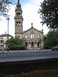
| Non-Subscribing Presbyterian Church, Main Street, Crumlin |
54°37′09″N 6°12′54″W |
Church |
Antrim |
A |
B+ |
HB20/15/007 |
 Upload another image
|
[18] |
| Galgorm Castle, Ballymena |
54°51′26″N 6°19′00″W |
Country House |
Ballymena |
– |
A |
HB07/15/001 A |
 Upload another image
See more images |
[19] |
| Moravian Church and 21 and 25 Church Road, Gracehill |
54°51′12″N 6°19′42″W |
Church |
Ballymena |
– |
A |
HB07/15/002 |
 Upload another image
See more images |
[20] |
| Early memorials in graveyard of Moravian Church, Gracehill |
54°51′12″N 6°19′42″W |
Memorial |
Ballymena |
– |
A |
HB07/15/003 |
 Upload another image
|
[21] |
| Benvarden, Ballybogey, Ballymoney |
55°08′14″N 6°30′58″W |
Country House |
Ballymoney |
– |
A |
HB04/02/002 |
 Upload another image
|
[22] |
| Leslie Hill, Ballypatrick, Ballymoney |
55°04′20″N 6°32′08″W |
Country House |
Ballymoney |
– |
A |
HB04/15/008 |
Upload Photo |
[23] |
| St. Peter's Cathedral, Belfast |
54°35′56″N 5°56′40″W |
Church |
Belfast |
– |
A |
HB26/33/003 |
 Upload another image
See more images |
[24] |
| St. Mark's Church, Holywood Road, Dundela, Belfast |
54°36′11″N 5°52′29″W |
Church |
Belfast |
– |
A |
HB26/12/017 |
 Upload another image
See more images |
[25] |
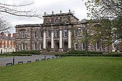
| Main Building, Stranmillis College, Stranmillis Road, Belfast |
54°34′24″N 5°56′04″W |
University/ College Building |
Belfast |
– |
A |
HB26/17/049 |
 Upload another image
See more images |
[26] |
| The Palm House, Belfast Botanic Gardens, Stranmillis Road, Belfast |
54°35′01″N 5°56′01″W |
Glass House |
Belfast |
– |
A |
HB26/27/003 |
 Upload another image
See more images |
[27] |
| Assembly's College (Theological College Of Presbyterian Church), Botanic Avenue, Belfast |
54°35′06″N 5°55′53″W |
University/ College Building |
Belfast |
– |
A |
HB26/27/004 |
 Upload another image
See more images |
[28] |
| Lanyon Building, Queen's University Belfast |
54°35′04″N 5°56′07″W |
University/ College Building |
Belfast |
– |
A |
HB26/27/005 |
 Upload another image
See more images |
[29] |
| Elmwood Hall, Elmwood Avenue, Belfast |
54°35′03″N 5°56′15″W |
Hall |
Belfast |
– |
A |
HB26/28/002 |
 Upload another image
See more images |
[30] |
| Grand Opera House, Great Victoria Street, Belfast |
54°35′43″N 5°56′06″W |
Entertainment Building |
Belfast |
– |
A |
HB26/29/001 |
 Upload another image
See more images |
[31] |
| Crown Liquor Saloon, 46 Great Victoria Street, Belfast |
54°35′41″N 5°56′03″W |
Public House |
Belfast |
– |
A |
HB26/30/003 |
 Upload another image
See more images |
[32] |
| St. Malachy's Church, Alfred Street, Belfast |
54°35′39″N 5°55′37″W |
Church |
Belfast |
– |
A |
HB26/30/023 |
 Upload another image
See more images |
[33] |
| Ulster Hall, 1–7 Bedford Street, Belfast |
54°35′41″N 5°55′50″W |
Entertainment Building |
Belfast |
A |
– |
HB26/30/057 |
 Upload another image
See more images |
[34] |
| St. Matthew's Church, Woodvale Road, Belfast |
54°36′24″N 5°57′37″W |
Church |
Belfast |
– |
A |
HB26/37/006 |
Upload Photo |
[35] |
| County Gaol, Crumlin Road, Belfast |
54°36′32″N 5°56′33″W |
Prison |
Belfast |
A |
B1 |
HB26/43/012 |
 Upload another image
See more images |
[36] |
| Belfast Charitable Institution (Clifton House), Clifton Street, Belfast |
54°36′23″N 5°56′00″W |
Residential Home |
Belfast |
– |
A |
HB26/49/001 |
 Upload another image
See more images |
[37] |
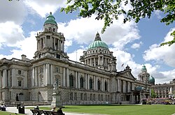
| Belfast City Hall, Donegall Square, Belfast |
54°35′48″N 5°55′49″W |
Town Hall |
Belfast |
– |
A |
HB26/50/001 |
 Upload another image
See more images |
[38] |
| First Marquis of Dufferin Memorial, Donegall Square, Belfast |
54°35′47″N 5°55′52″W |
Memorial |
Belfast |
– |
A |
HB26/50/002 |
 Upload another image
See more images |
[39] |
| Boer War Monument, Donegall Square, Belfast |
54°35′47″N 5°55′44″W |
Memorial |
Belfast |
– |
A |
HB26/50/003 |
 Upload another image
See more images |
[40] |
| Cenotaph and Garden of Remembrance, Donegall Square, Belfast |
54°35′46″N 5°55′51″W |
Memorial |
Belfast |
– |
A |
HB26/50/005 |
 Upload another image
See more images |
[41] |
| Titanic Monument, Donegall Square, Belfast |
54°35′48″N 5°55′44″W |
Memorial |
Belfast |
– |
A |
HB26/50/006 |
 Upload another image
See more images |
[42] |
| Sir Edward Harland Memorial, Donegall Square, Belfast |
54°35′49″N 5°55′45″W |
Memorial |
Belfast |
– |
A |
HB26/50/007 |
 Upload another image
See more images |
[43] |
| Sir Robert McMordie Memorial, Donegall Square, Belfast |
54°35′49″N 5°55′52″W |
Memorial |
Belfast |
– |
A |
HB26/50/008 |
 Upload another image
See more images |
[44] |
| Sir Daniel Dixon Monument, Donegall Square, Belfast |
54°35′49″N 5°55′51″W |
Memorial |
Belfast |
– |
A |
HB26/50/009 |
Upload Photo |
[45] |
| Victoria Monument, Donegall Square, Belfast |
54°35′49″N 5°55′48″W |
Memorial |
Belfast |
– |
A |
HB26/50/010 |
 Upload another image
See more images |
[46] |
| Sir James Haslett Memorial, Donegall Square, Belfast |
54°35′49″N 5°55′45″W |
Memorial |
Belfast |
– |
A |
HB26/50/011 |
 Upload another image
See more images |
[47] |
| Former Water Office, 1 Donegall Square, Belfast |
54°35′51″N 5°55′45″W |
Shop |
Belfast |
– |
A |
HB26/50/015 |
 Upload another image
See more images |
[48] |
| Royal Belfast Academical Institution, College Square, Belfast |
54°35′49″N 5°56′11″W |
School |
Belfast |
– |
A |
HB26/50/023 |
 Upload another image
See more images |
[49] |
| St. George's Church, High Street, Belfast |
54°36′01″N 5°55′30″W |
Church |
Belfast |
– |
A |
HB26/50/045 |
 Upload another image
See more images |
[50] |
| McCausland's Building (Hotel), 34-38 Victoria Street, Belfast |
54°36′00″N 5°55′27″W |
Office |
Belfast |
– |
A |
HB26/50/046 |
 Upload another image
|
[51] |
| First Presbyterian Church (Non-Subscribing), 41 Rosemary Street, Belfast |
54°36′01″N 5°55′47″W |
Church |
Belfast |
– |
A |
HB26/50/054 |
 Upload another image
|
[52] |
| Former Ulster Bank Head Office, Waring Street, Belfast |
54°36′04″N 5°55′32″W |
Hotel |
Belfast |
– |
A |
HB26/50/058 |
 Upload another image
See more images |
[53] |
| Custom House, Custom House Square, Belfast |
54°36′06″N 5°55′22″W |
Office |
Belfast |
– |
A |
HB26/50/062 |
 Upload another image
See more images |
[54] |
| St. Anne's Cathedral, Donegall Street, Belfast |
54°36′10″N 5°55′44″W |
Church |
Belfast |
– |
A |
HB26/50/067 |
 Upload another image
See more images |
[55] |
| Clarendon Building, Clarendon Quay, Belfast |
54°36′22″N 5°55′15″W |
Office |
Belfast |
A |
A |
HB26/50/090 A |
Upload Photo |
[56] |
| Harbour Office, Corporation Square, Belfast |
54°36′19″N 5°55′19″W |
Office |
Belfast |
– |
A |
HB26/50/094 |
 Upload another image
|
[57] |
| Tesco (former Provincial Bank of Ireland), 2 Royal Avenue, Belfast |
54°35′58″N 5°55′51″W |
Bank |
Belfast |
– |
A |
HB26/50/106 |
 Upload another image
|
[58] |
| Old Museum Buildings, 7 College Square, Belfast |
54°35′51″N 5°56′18″W |
Gallery/ Museum |
Belfast |
– |
A |
HB26/50/112 B |
 Upload another image
|
[59] |
| Royal Courts Of Justice, Chichester Street, Belfast |
54°35′50″N 5°55′20″W |
Court House |
Belfast |
– |
A |
HB26/50/180 |
 Upload another image
See more images |
[60] |
| McHugh's Bar, 31-33 Queen's Square, Belfast |
54°36′03″N 5°55′23″W |
Public House |
Belfast |
– |
A |
HB26/50/274 |
 Upload another image
See more images |
[61] |
| St. Nicholas' Church, Lancasterian Street, Carrickfergus |
54°42′54″N 5°48′31″W |
Church |
Carrickfergus |
– |
A |
HB22/08/001 |
 Upload another image
See more images |
[62] |
| Castle Dobbs, Tongue Loanen, Carrickfergus |
54°44′38″N 5°45′30″W |
Country House |
Carrickfergus |
A |
A |
HB22/13/001 A |
Upload Photo |
[63] |
| Glenarm Castle, Glenarm |
54°57′58″N 5°57′24″W |
Country House |
Larne |
A |
A |
HB06/02/001 A |
 Upload another image
See more images |
[64] |
| Ballygally Castle, Coast Road, Ballygalley, Larne |
54°53′56″N 5°51′42″W |
Hotel |
Larne |
A |
A |
HB06/03/011 |
 Upload another image
See more images |
[65] |
| The Brewhouse and walling, Red Hall, Ballycarry |
54°46′54″N 5°44′51″W |
House |
Larne |
A |
A |
HB06/05/013 A |
Upload Photo |
[66] |
| Red Hall, Ballycarry |
54°46′53″N 5°44′51″W |
Country House |
Larne |
A |
A |
HB06/05/013 B |
Upload Photo |
[67] |
| 4 Trummery Lane, Trummery, Maghaberry |
54°29′59″N 6°11′18″W |
House |
Lisburn |
A |
A |
HB19/03/048 |
Upload Photo |
[68] |
| Christ Church Cathedral, Market Square, Lisburn |
54°30′40″N 6°02′35″W |
Church |
Lisburn |
A |
A |
HB19/16/001 |
 Upload another image
See more images |
[69] |
| Fountain, Castle Gardens, Lisburn |
54°30′43″N 6°02′25″W |
Fountain |
Lisburn |
– |
A |
HB19/16/015 |
 Upload another image
|
[70] |
| Christ Church, Derriaghy, Lisburn |
54°32′33″N 6°01′56″W |
Church |
Lisburn |
– |
A |
HB19/18/008 |
 Upload another image
See more images |
[71] |
| First Presbyterian Church (Non-Subscribing), Dunmurry |
54°33′03″N 6°00′27″W |
Church |
Lisburn |
– |
A |
HB19/20/005 |
Upload Photo |
[72] |
| Holy Trinity Church, The Diamond, Ballycastle |
55°12′02″N 6°15′00″W |
Church |
Moyle |
A |
A |
HB05/14/001 |
 Upload another image
See more images |
[73] |
| Railway Viaduct (1), Bleach Green Junction, Newtownabbey |
54°40′51″N 5°54′10″W |
Viaduct |
Newtownabbey |
A |
B1 |
HB21/10/001 A |
Upload Photo |
[74] |
| Railway Viaduct (2), Bleach Green Junction, Newtownabbey |
54°40′51″N 5°54′08″W |
Viaduct |
Newtownabbey |
A |
B1 |
HB21/10/001 B |
Upload Photo |
[75] |
| Church of St Patrick, Jordanstown Road, Jordanstown |
54°41′20″N 5°53′56″W |
Church |
Newtownabbey |
A |
A |
HB21/11/001 |
Upload Photo |
[76] |


_Presbyterian_Church_-_geograph.org.uk_-_67942.jpg)

,_September_2009.JPG)


.JPG)


.jpg)


_-_geograph.org.uk_-_383944.jpg)


.JPG)
,_October_2009.JPG)
.JPG)
_41_Rosemary_St._Belfast.jpg)


.jpg)
.jpg)

,_October_2009.JPG)


_-_geograph.org.uk_-_58794.jpg)
