| Name |
Location |
Date Listed |
Grid Ref. [note 1] |
Geo-coordinates |
Notes |
LB Number [note 2] |
Image |
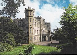
| Torwoodlee House |
Torwoodlee, Galashiels |
|
NT4718237978 |
55°37′57″N 2°50′26″W |
Mansion built c. 1783.[5] |
135
|  Upload another image
|
| Cranshaws Church |
Cranshaws |
|
NT6923161843 |
55°50′56″N 2°29′35″W |
Romanesque revival church built 1899.[6] |
201
|  Upload another image
See more images
|
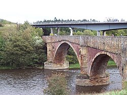
| Old Ancrum Bridge |
Ancrum |
|
NT6387123750 |
55°30′22″N 2°34′25″W |
Late 18th century bridge with three arches.[7] |
224
|  Upload another image
See more images
|
| Parish Church of St Cuthbert |
Channelkirk, Oxton |
|
NT4815254505 |
55°46′52″N 2°49′42″W |
Dated 1817.[8] |
1893
|  Upload another image
See more images
|
| Yair House |
Yair |
|
NT4529132854 |
55°35′10″N 2°52′10″W |
Georgian mansion built by Alexander Pringle of Whytbank.[9] |
1899
|  Upload another image
See more images
|
| Yair Bridge |
Yair |
|
NT4581532554 |
55°35′01″N 2°51′40″W |
Mid-18th century 3 arched bridge spanning the Tweed.[10] |
1901
|  Upload another image
See more images
|
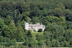
| Ashiestiel House |
Ashiestiel |
|
NT4303835143 |
55°36′24″N 2°54′21″W |
Home of Walter Scott between 1804 and 1812[11] |
1902 |

Upload Photo
|
| Ashiestiel Bridge |
Ashiestiel |
|
NT4386735076 |
55°36′22″N 2°53′33″W |
Single arch spanning the Tweed, built 1847.[12] |
1903
|  Upload another image
|
| Peel Hospital |
Ashiestiel |
|
NT4316735079 |
55°36′22″N 2°54′13″W |
Built as a Baronial style mansion c. 1904-07.[13] |
1904
|  Upload another image
|
| Bowden Church and Graveyard |
Bowden |
|
NT5543330150 |
55°33′47″N 2°42′29″W |
Early 17th century.[14] |
1920
|  Upload another image
See more images
|
| The Retreat |
Abbey St Bathans |
|
NT7716360894 |
55°50′27″N 2°21′58″W |
Late 18th century former hunting lodge.[15] |
1971
|  Upload another image
|
| Ayton Castle |
Ayton |
|
NT9289561379 |
55°50′44″N 2°06′54″W |
A large Scots Baronial house, built 1845-51 by James Gillespie Graham.[16] |
1987
|  Upload another image
See more images
|
| Ayton Castle, Dovecot |
Ayton |
|
NT9302361455 |
55°50′47″N 2°06′47″W |
16th century circular-plan beehive dovecot.[17] |
1989 |
Upload Photo
|
| Broughton Place |
Broughton, Glenholm and Kilbucho |
|
NT1169137236 |
55°37′14″N 3°24′14″W |
Scottish country house designed by Sir Basil Spence, 1935-1938, with later alterations.[18] |
2031
|  Upload another image
See more images
|
| Portmore House |
Eddleston |
|
NT2504448832 |
55°43′37″N 3°11′42″W |
Baronial style mansion, built 1850 by David Bryce, restored after fire in 1883.[19] |
2037 |
Upload Photo
|
| Westgate Hall |
Denholm |
|
NT5678918307 |
55°27′24″N 2°41′05″W |
17th century.[20] |
2052
|  Upload another image
See more images
|
| Crailing House |
Crailing |
|
NT6886224362 |
55°30′43″N 2°29′41″W |
Built 1803, designed by local architect, William Elliot.[21] |
2080 |
Upload Photo
|
| Cowdenknowes |
Earlston |
|
NT5772837038 |
55°37′30″N 2°40′22″W |
16th century mansion house.[22] |
2120
|  Upload another image
|
| Mellerstain House |
Gordon |
|
NT6476539095 |
55°38′39″N 2°33′41″W |
The two wings built 1725 by William Adam, the main block by his son Robert about 40 years later.[23] |
2123
|  Upload another image
See more images
|
| Mellerstain House, Stables and Cottage Block |
Gordon |
|
NT6471939101 |
55°38′39″N 2°33′44″W |
[24] |
2124 |
Upload Photo
|
| Edrom Parish Church |
Edrom |
|
NT8276055835 |
55°47′44″N 2°16′36″W |
Cross-plan church rebuilt 1737 utilising foundations of earlier church. 1886 Restoration with additions.[25] |
2127
|  Upload another image
See more images
|
| Nisbet House |
Duns |
|
NT7950151232 |
55°45′14″N 2°19′41″W |
[26] |
2131
|  Upload another image
See more images
|
| Nisbet Dovecot |
Nisbethill, Duns |
|
NT7965350617 |
55°44′55″N 2°19′33″W |
Unique pentagon-plan dovecot, built late 18th century.[27] |
2132
|  Upload another image
See more images
|
| Kalemouth Suspension Bridge, over River Teviot |
Kalemouth |
|
NT7084227453 |
55°32′24″N 2°27′49″W |
Chain-link suspension bridge, 180 ft (55 m) long, built c. 1830.[28] |
3849
|  Upload another image
See more images
|
| Wedderburn Castle, Lion Gate and Boundary Walls |
Duns |
|
NT8053053228 |
55°46′19″N 2°18′43″W |
Built 1790s.[29] |
4029
|  Upload another image
See more images
|
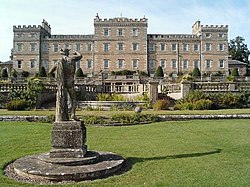
| Manderston |
Duns |
|
NT8107554377 |
55°46′56″N 2°18′12″W |
Classical house c. 1790, with reconstruction and extension by John Kinross, 1901-5.[30] |
4033
|  Upload another image
See more images
|
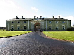
| Manderston, Stables |
Duns |
|
NT8079854640 |
55°47′05″N 2°18′28″W |
Stable and carriage house block, dated 1895, by John Kinross.[31] |
4034
|  Upload another image
|
| Old Manor House (Sparrow Castle) |
Cockburnspath |
|
NT7747771049 |
55°55′55″N 2°21′43″W |
[32] |
4046 |
Upload Photo
|
| Market Cross |
Cockburnspath, The Square |
|
NT7743071100 |
55°55′57″N 2°21′46″W |
[33] |
4047
|  Upload another image
See more images
|
| Pease Bridge |
A1107, Cockburnspath |
|
NT7915369977 |
55°55′21″N 2°20′07″W |
Built 1786, with 4 arches spanning the Pease Glen.[34] |
4054
|  Upload another image
|
| Coldingham Priory |
Coldingham |
|
NT9039465949 |
55°53′12″N 2°09′19″W |
On the site of an 11th century church which has been damaged and rebuilt several times. Remodeled in 1662 with further work in 1851-55.[35] |
4059
|  Upload another image
See more images
|
| Lennel House |
Coldstream |
|
NT8515140784 |
55°39′37″N 2°14′15″W |
[36] |
4068
|  Upload another image
|
| The Hirsel |
Coldstream |
|
NT8294440745 |
55°39′36″N 2°16′22″W |
Georgian house, mostly early 18th century, with Victorian alterations and additions.[37] |
4069
|  Upload another image
See more images
|
| Coldstream Bridge |
Coldstream |
|
NT8488040130 |
55°39′16″N 2°14′31″W |
Built 1763-66 by John Smeaton with 20th century alterations[38][note 3] |
4075
|  Upload another image
See more images
|
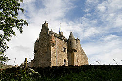
| Cranshaws Castle |
Cranshaws |
|
NT6819561807 |
55°50′54″N 2°30′34″W |
Possibly late 14th century with later alterations.[39] |
4093
|  Upload another image
See more images
|
| Market Cross |
Coldingham, The Square |
|
NT9023665974 |
55°53′13″N 2°09′28″W |
Dated 1815.[40] |
4094
|  Upload another image
|
| Renton House |
Grantshouse |
|
NT8227465304 |
55°52′50″N 2°17′06″W |
Early 18th century with later additions and alterations.[41] |
4105
|  Upload another image
|
| Duns Castle |
Duns |
|
NT7777554384 |
55°46′56″N 2°21′21″W |
Tower house, c. 1320, incorporated in substantial later additions and alterations.[42] |
4108
|  Upload another image
See more images
|
| Bughtrig House |
Leitholm |
|
NT7959644797 |
55°41′46″N 2°19′34″W |
Late 18th to early 19th century house remodelled late 19th century.[43] |
4114
|  Upload another image
|
| Kames House |
Leitholm |
|
NT7826145464 |
55°42′08″N 2°20′51″W |
[44] |
4115 |
Upload Photo
|
| Preston Bridge |
Preston |
|
NT7872056783 |
55°48′14″N 2°20′28″W |
Humped-back 3-arched bridge dated 1770.[45] |
4120
|  Upload another image
|
| Ninewells Dovecot |
Chirnside, Kirkgate |
|
NT8699756167 |
55°47′55″N 2°12′32″W |
16th century.[46] |
4124 |
Upload Photo
|
| Cockburnspath Church and Graveyard |
Cockburnspath |
|
NT7744571053 |
55°55′55″N 2°21′45″W |
[47] |
4129
|  Upload another image
See more images
|
| Chesters House |
Ancrum |
|
NT6084222512 |
55°29′41″N 2°37′17″W |
Late 18th century.[48] |
4174
|  Upload another image
See more images
|
| Dovecot, Knowesouth |
Bedrule |
|
NT6068321419 |
55°29′06″N 2°37′25″W |
Late 18th century.[49] |
4182 |
Upload Photo
|
| Chirnside Primary School |
Chirnside |
|
NT8712456118 |
55°47′53″N 2°12′25″W |
Built by Reid and Forbes, 1937-1938, with later additions and alterations.[50] |
6620
|  Upload another image
|
| Kirkhope Tower |
Ettrickbridge |
|
NT3787225053 |
55°30′55″N 2°59′08″W |
[51] |
6720
|  Upload another image
See more images
|
| Market Cross |
Greenlaw, The Square |
|
NT7114346038 |
55°42′25″N 2°27′39″W |
[52] |
6823
|  Upload another image
|
| Thirlestane Castle |
Lauder |
|
NT5338547902 |
55°43′20″N 2°44′37″W |
Late 16th century with later additions and alterations.[53] |
8203
|  Upload another image
See more images
|
| The Kirna, also known as Kirna House, and Grangehill |
Walkerburn |
|
NT3507637417 |
55°37′34″N 3°01′57″W |
Built by F T Pilkington, 1867, for George Ballantyne.[54] |
8323
|  Upload another image
See more images
|
| Prefabricated cast-iron urinal |
Walkerburn, Galashiels Road |
|
NT3588637179 |
55°37′26″N 3°01′11″W |
Built c. 1897.[55] |
8326
|  Upload another image
|
| Longformacus House |
Longformacus |
|
NT6958257305 |
55°48′29″N 2°29′13″W |
Early 18th century with 18th and 19th century additions and alterations.[56] |
8344
|  Upload another image
See more images
|
| Longformacus House, Dovecot |
Longformacus |
|
NT6956557384 |
55°48′32″N 2°29′14″W |
Early to mid 18th century.[57] |
8345
|  Upload another image
|
| St Mary's Church, Ladykirk |
Ladykirk |
|
NT8887647660 |
55°43′20″N 2°10′43″W |
[58] |
8349
|  Upload another image
See more images
|
| West Lodge, Ladykirk House |
Ladykirk |
|
NT8747245457 |
55°42′09″N 2°12′03″W |
Dated 1799.[59] |
8351
|  Upload another image
|
| Spitalhaugh House |
West Linton |
04/11/2010 |
NT1627049662 |
55°43′59″N 3°20′05″W |
[60] |
8361 |
Upload Photo
|
| Tentyfoot Tower |
Branxholme |
|
NT4643911687 |
55°23′46″N 2°50′50″W |
[61] |
8397 |
Upload Photo
|
| Floors Castle |
Kelso |
|
NT7111034670 |
55°36′17″N 2°27′36″W |
Built by William Adam, 1721-6, possibly incorporating earlier fabric, and remodelled by W H Playfair, 1837-1845.[62] |
10480
|  Upload another image
See more images
|
| Greenlaw Church |
Greenlaw |
|
NT7116246152 |
55°42′29″N 2°27′38″W |
[63] |
10490
|  Upload another image
See more images
|
| Old Market Cross in Churchyard |
Greenlaw |
|
NT7115046146 |
55°42′28″N 2°27′38″W |
[64] |
10491
|  Upload another image
|
| Greenlaw Court House |
Greenlaw, The Square |
|
NT7113946064 |
55°42′26″N 2°27′39″W |
Built 1829, architect was John Cunningham.[65] |
10492
|  Upload another image
See more images
|
| Castle Inn |
Greenlaw, The Square |
|
NT7114345992 |
55°42′23″N 2°27′39″W |
Early 19th century.[66] |
10493 |
Upload Photo
|
| Paxton House |
Paxton |
|
NT9319751977 |
55°45′40″N 2°06′36″W |
[67] |
10506
|  Upload another image
See more images
|
| Fogo Kirk |
Fogo |
|
NT7725749196 |
55°44′08″N 2°21′49″W |
[68] |
10512
|  Upload another image
See more images
|
| Fogo Bridge |
Fogo |
|
NT7698149203 |
55°44′08″N 2°22′05″W |
Single span round-arched bridge dated 1641 and rebuilt 1843.[69] |
10513
|  Upload another image
|
| Gifford Stones House |
West Linton, Main Street |
|
NT1500251814 |
55°45′08″N 3°21′21″W |
Late 19th century with elaborately carved 17th century stone inset panels.[70] |
12888 |
Upload Photo
|
| Glenmayne House |
Galashiels |
|
NT4984833737 |
55°35′41″N 2°47′51″W |
[71] |
12929
|  Upload another image
|
| Nether Road, Gala Fairydean Football Stadium |
|
|
|
55°36′23″N 2°47′03″W |
|
50711
|  Upload another image
See more images
|
| Stoneyhill House |
Walkerburn, Galashiels Road |
|
NT3629537267 |
55°37′29″N 3°00′48″W |
[72] |
12930 |
Upload Photo
|
| Scott-Douglas Mausoleum |
Springwood, Kelso |
|
NT7142233567 |
55°35′42″N 2°27′18″W |
Neo-classical temple mausoleum by James Gillespie Graham, c. 1820 – c. 1825[73] |
12952
|  Upload another image
|
| Edgerston House |
Jedburgh |
|
NT6904011563 |
55°23′49″N 2°29′25″W |
[74] |
13360 |
Upload Photo
|
| Ferniehurst Castle |
Jedburgh |
|
NT6523517969 |
55°27′16″N 2°33′04″W |
Late 16th century, considerably altered subsequently and restored 1883, 1938 and 1987-90.[75] |
13369
|  Upload another image
See more images
|
| Ferniehurst Castle, Visitor Centre (Former Chapel) |
Jedburgh |
|
NT6525518022 |
55°27′17″N 2°33′03″W |
[76] |
13370
|  Upload another image
|
| Glenburn Hall |
Jedburgh |
|
NT6419220075 |
55°28′23″N 2°34′05″W |
Built c. 1815[77] |
13371 |
Upload Photo
|
| Leithen Lodge |
Innerleithen |
|
NT3208642789 |
55°40′26″N 3°04′53″W |
Early 19th century, with later additions and alterations.[78] |
13475
|  Upload another image
|
| Union Suspension Bridge |
Hutton, Fishwick |
|
NT9339151025 |
55°45′09″N 2°06′25″W |
[79][note 4] |
13645
|  Upload another image
See more images
|
| Branxholme Castle |
Branxholme |
|
NT4644311667 |
55°23′46″N 2°50′50″W |
[80] |
13686
|  Upload another image
See more images
|
| Swinton House, Dovecot |
Swinton |
|
NT8146346888 |
55°42′54″N 2°17′48″W |
Dated 1746 and repaired later 20th century.[81] |
13850 |
Upload Photo
|
| Neidpath Castle |
Peebles |
|
NT2361840487 |
55°39′07″N 3°12′55″W |
[82] |
13857
|  Upload another image
See more images
|
| Harden |
Roberton |
|
NT4493814885 |
55°25′29″N 2°52′17″W |
17th century with later additions.[83] |
15089 |
Upload Photo
|
| Railway Viaduct over the River Teviot |
Roxburgh |
|
NT7020030413 |
55°33′59″N 2°28′27″W |
[84] |
15097
|  Upload another image
See more images
|
| Abbotsford |
Melrose |
|
NT5081534266 |
55°35′58″N 2°46′56″W |
[85] |
15104
|  Upload another image
See more images
|
| Drygrange Old Bridge |
Leaderfoot, Newstead |
|
NT5753034668 |
55°36′14″N 2°40′32″W |
Late 18th century bridge crossing the River Tweed.[86] |
15106
|  Upload another image
See more images
|
| Mertoun House |
St Boswells |
|
NT6178931722 |
55°34′40″N 2°36′27″W |
[87] |
15110
|  Upload another image
See more images
|
| Mertoun House, Dovecot |
St Boswells |
|
NT6201831894 |
55°34′45″N 2°36′14″W |
Dated 1576.[88] |
15112
|  Upload another image
|
| Dryburgh Abbey memorials |
Dryburgh, St Boswells |
|
NT5915831703 |
55°34′38″N 2°38′58″W |
[89] |
15114
|  Upload another image
See more images
|
| Bemersyde House |
Bemersyde |
|
NT5921633328 |
55°35′31″N 2°38′55″W |
[90] |
15120
|  Upload another image
See more images
|
| Leaderfoot Viaduct |
Leaderfoot, Newstead |
|
NT5738534743 |
55°36′16″N 2°40′41″W |
Former railway viaduct spanning the River Tweed, built 1865.[91] |
15145
|  Upload another image
See more images
|
| Sundial, Lamancha |
West Linton |
|
NT1995452238 |
55°45′25″N 3°16′37″W |
Late 17th century.[92] |
15177
|  Upload another image
|
| The Haining |
Selkirk |
|
NT4689728028 |
55°32′35″N 2°50′35″W |
[93] |
15190
|  Upload another image
See more images
|
| The Haining, Stables |
Selkirk |
|
NT4681028021 |
55°32′35″N 2°50′40″W |
[94] |
15191
|  Upload another image
|
| Aikwood Tower |
Selkirk |
|
NT4200626042 |
55°31′29″N 2°55′13″W |
Early 17th century tower.[95] |
15195
|  Upload another image
See more images
|
| Bowhill House |
Selkirk |
|
NT4258227810 |
55°32′26″N 2°54′41″W |
[96] |
15196
|  Upload another image
See more images
|
| Neidpath Railway Viaduct |
Peebles |
|
NT2328340195 |
55°38′57″N 3°13′14″W |
Former railway viaduct crossing the River Tweed, opened 1864.[97] |
15206
|  Upload another image
See more images
|
| Newton Don |
Stichill |
|
NT7091137200 |
55°37′39″N 2°27′49″W |
[98] |
15220
|  Upload another image
|
| Swinton House |
Swinton |
|
NT8182547086 |
55°43′01″N 2°17′27″W |
Dated 1800 with later additions and alterations.[99] |
15339 |
Upload Photo
|
| Barns House, Stables |
Peebles |
|
NT2151039112 |
55°38′21″N 3°14′54″W |
[100] |
15362 |
Upload Photo
|
| Stobo Castle |
Stobo, Peebles |
|
NT1729836660 |
55°36′59″N 3°18′53″W |
[101] |
15379
|  Upload another image
See more images
|
| Polwarth Church |
Polwarth |
|
NT7499549492 |
55°44′17″N 2°23′59″W |
[102] |
15384
|  Upload another image
See more images
|
| Marchmont House |
Greenlaw |
|
NT7432248498 |
55°43′45″N 2°24′38″W |
[103] |
15386
|  Upload another image
See more images
|
| Marchmont Estate, Dovecot |
Greenlaw |
|
NT7600149889 |
55°44′30″N 2°23′02″W |
[104] |
15388
|  Upload another image
|
| Traquair House |
Traquair |
|
NT3307435480 |
55°36′30″N 3°03′50″W |
[105] |
15429
|  Upload another image
See more images
|
| Traquair House, Bear Gates and Avenue Head Cottages |
Traquair |
|
NT3262335159 |
55°36′19″N 3°04′16″W |
[106] |
15430
|  Upload another image
See more images
|
| Kailzie, Dovecote |
Peebles |
|
NT2818738633 |
55°38′09″N 3°08′32″W |
Dated 1698.[107] |
15439 |
Upload Photo
|
| Lessudden House |
St Boswells |
|
NT5987431429 |
55°34′29″N 2°38′17″W |
[108] |
17412
|  Upload another image
|
| Hoselaw Chapel |
Kirk Yetholm |
|
NT8016831758 |
55°34′45″N 2°18′58″W |
[109] |
18799
|  Upload another image
See more images
|
| Traquair House, Summerhouse |
Traquair |
|
NT3294235197 |
55°36′21″N 3°03′57″W |
Dated 1834.[110] |
19391
|  Upload another image
See more images
|
| The Studio (former Bernat Klein Studio) |
High Sunderland, Selkirk |
|
NT4737631377 |
55°34′24″N 2°50′10″W |
Late Modernist building, 1972, designed by Peter Womersley.[111] |
19484
|  Upload another image
See more images
|
| Whim House, Court of Offices |
West Linton |
|
NT2140253578 |
55°46′09″N 3°15′16″W |
[112] |
19724 |
Upload Photo
|
| Wedderlie House |
Westruther |
|
NT6394151535 |
55°45′21″N 2°34′34″W |
[113] |
19740
|  Upload another image
|
| The Glen |
Traquair |
|
NT2980233044 |
55°35′09″N 3°06′55″W |
[114] |
19746
|  Upload another image
See more images
|
| Chester House |
Eyemouth, Church Street |
|
NT9450364241 |
55°52′17″N 2°05′22″W |
Mid 18th century.[115] |
31128 |
Upload Photo
|
| Gunsgreen House |
Eyemouth |
|
NT9474564368 |
55°52′21″N 2°05′08″W |
[116] |
31133
|  Upload another image
See more images
|
| Old Gala House |
Galashiels, Scott Crescent |
|
NT4916535897 |
55°36′50″N 2°48′31″W |
[117] |
31973
|  Upload another image
See more images
|
| Kingsknowes |
Galashiels, Selkirk Road |
|
NT5074134737 |
55°36′13″N 2°47′00″W |
[118] |
31999 |
Upload Photo
|
| Woodlands |
Galashiels, Windyknowe Road |
|
NT4848236520 |
55°37′10″N 2°49′10″W |
[119] |
32002 |
Upload Photo
|
| Tower Mill |
Hawick, Kirkstile |
|
NT5020014429 |
55°25′16″N 2°47′18″W |
[120] |
34619
|  Upload another image
|
| Hawick Town Hall |
Hawick, High Street |
|
NT5034114559 |
55°25′21″N 2°47′12″W |
[121] |
34634
|  Upload another image
See more images
|
| Equestrian Statue |
Hawick, High Street |
|
NT5042814790 |
55°25′28″N 2°47′05″W |
[122] |
34645
|  Upload another image
|
| Newgate |
Jedburgh, Abbey Place |
|
NT6499420531 |
55°28′38″N 2°33′19″W |
[123] |
35457
|  Upload another image
|
| Canongate Bridge |
Jedburgh |
|
NT6526020597 |
55°28′41″N 2°33′04″W |
16th century.[124] |
35471
|  Upload another image
See more images
|
| Jedburgh Castle Old Jail |
Jedburgh, Castlegate |
|
NT6476120184 |
55°28′27″N 2°33′32″W |
[125] |
35482
|  Upload another image
See more images
|
| 3-5 (Odd Nos) Exchange Street |
Jedburgh |
|
NT6498620594 |
55°28′40″N 2°33′20″W |
[126] |
35520
|  Upload another image
|
| 11 Exchange Street |
Jedburgh |
|
NT6496420612 |
55°28′41″N 2°33′21″W |
[127] |
35522
|  Upload another image
See more images
|
| Jedburgh Old Parish Church |
Jedburgh, Newcastle Road |
|
NT6508420235 |
55°28′29″N 2°33′14″W |
[128] |
35581
|  Upload another image
See more images
|
| St John's Episcopal Church |
Jedburgh, The Pleasance |
|
NT6509620983 |
55°28′53″N 2°33′14″W |
[129] |
35589
|  Upload another image
See more images
|
| Queen Mary's House |
Jedburgh, Queen Street |
|
NT6516220674 |
55°28′43″N 2°33′10″W |
Late 16th century house.[130] |
35591
|  Upload another image
See more images
|
| Kelso Old Parish Church |
Kelso, Abbey Row |
|
NT7293033909 |
55°35′53″N 2°25′52″W |
[131] |
35696
|  Upload another image
See more images
|
| Ednam House Hotel |
Kelso, Bridge Street |
|
NT7271733836 |
55°35′51″N 2°26′04″W |
[132] |
35716
|  Upload another image
|
| Bridge-End Cottage |
Kelso, Bridge Street |
|
NT7282333669 |
55°35′45″N 2°25′58″W |
[133] |
35724 |
Upload Photo
|
| Kelso Bridge |
Kelso |
|
NT7279133614 |
55°35′43″N 2°26′00″W |
Built 1800-1803 to replace a bridge destroyed in a flood in 1797.[134] |
35764
|  Upload another image
See more images
|
| St John's Edenside and Ednam Church Of Scotland |
Kelso, Roxburgh Street |
|
NT7257234201 |
55°36′02″N 2°26′13″W |
[135] |
35800
|  Upload another image
See more images
|
| Walton Hall |
Kelso, Roxburgh Street |
|
NT7233434309 |
55°36′06″N 2°26′26″W |
[136] |
35805 |
Upload Photo
|
| Walton Hall, entrance gateways and wall |
Kelso, Roxburgh Street |
|
NT7233434309 |
55°36′06″N 2°26′26″W |
[137] |
35806 |
Upload Photo
|
| Floors Castle, gates and gate lodges |
Kelso |
|
NT7219934419 |
55°36′09″N 2°26′34″W |
[138] |
35811
|  Upload another image
|
| Springwood Park, Gateway and Gates |
Kelso |
|
NT7265033461 |
55°35′38″N 2°26′08″W |
[139] |
35826 |
Upload Photo
|
| Teviot Bridge |
Kelso |
|
NT7198433547 |
55°35′41″N 2°26′46″W |
[140] |
35847
|  Upload another image
|
| Lauder Church |
Lauder, East High Street |
|
NT5309347533 |
55°43′08″N 2°44′54″W |
[141] |
37200
|  Upload another image
See more images
|
| Darnick Tower |
Darnick, Tower Road |
|
NT5320234375 |
55°36′03″N 2°44′39″W |
[142] |
37756
|  Upload another image
See more images
|
| Market Cross |
Melrose, Market Square |
|
NT5476833973 |
55°35′50″N 2°43′10″W |
[143] |
37794
|  Upload another image
|
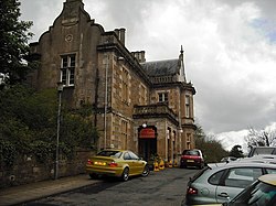
| Melrose railway station |
Melrose, Palma Place |
|
NT5468333912 |
55°35′48″N 2°43′14″W |
Opened 1849.[144] |
37803
|  Upload another image
See more images
|
| St Helen's |
Melrose, Waverley Road |
|
NT5365734721 |
55°36′14″N 2°44′14″W |
[145] |
37811 |
Upload Photo
|
| Chambers Institution |
Peebles, High Street |
|
NT2525940443 |
55°39′06″N 3°11′21″W |
[146] |
39180
|  Upload another image
See more images
|
| Town House |
Peebles, High Street |
|
NT2522640419 |
55°39′05″N 3°11′23″W |
[147] |
39188
|  Upload another image
See more images
|
| Tweed Bridge |
Peebles |
|
NT2504340305 |
55°39′02″N 3°11′34″W |
[148] |
39278
|  Upload another image
See more images
|
| Town House, Old Sheriff Court |
Selkirk, Market Place |
|
NT4702628477 |
55°32′50″N 2°50′28″W |
[149] |
40569
|  Upload another image
See more images
|
| Ettrick Mill |
Selkirk, Dunsdale Road |
|
NT4716829288 |
55°33′16″N 2°50′21″W |
Mid 19th century woollen spinning and tweed manufacturing complex.[150] |
40578
|  Upload another image
See more images
|
| War Memorial |
Selkirk, Ettrick Terrace |
|
NT4691728538 |
55°32′52″N 2°50′34″W |
[151] |
40581
|  Upload another image
|
| Manderston, Boat House and Gateway |
Duns |
|
NT8107854221 |
55°46′51″N 2°18′12″W |
Swiss chalet style boat house, built 1894 by John Kinross.[152] |
42505 |
Upload Photo
|
| Manderston, Buxley, Dairy Court |
Duns |
|
NT8095654774 |
55°47′09″N 2°18′19″W |
[153] |
42508
|  Upload another image
|
| Manderston, Buxley, Dairy Tower with Unicorn Stair |
Duns |
|
NT8096854773 |
55°47′09″N 2°18′18″W |
[154] |
42510
| Upload another image
|
| Manderston, Buxley, Engineer's House |
Duns |
|
NT8090954814 |
55°47′11″N 2°18′22″W |
[155] |
42511 |
Upload Photo
|
| Manderston, Buxley, Fire Station and Engine House |
Duns |
|
NT8093954828 |
55°47′11″N 2°18′20″W |
[156] |
42514 |
Upload Photo
|
| Manderston, Buxley, Head Gardener's House |
Duns |
|
NT8090154784 |
55°47′10″N 2°18′22″W |
[157] |
42516 |
Upload Photo
|
| Manderston, Pheasantry Wood, Gamekeeper's Cottage with Dovecot |
Duns |
|
NT8155354434 |
55°46′58″N 2°17′44″W |
[158] |
42528 |
Upload Photo
|
| Manderston, Terraces to south and east, including Ram's Horn Stair, urns, Mercury Statue and Griffin Gate |
Duns |
|
NT8110554354 |
55°46′56″N 2°18′10″W |
[159] |
42534 |
Upload Photo
|
| Wedderburn Castle |
Duns |
|
NT8083852854 |
55°46′07″N 2°18′25″W |
[160] |
42543
|  Upload another image
See more images
|
| Nisbet House, Stable and Coach House |
Duns |
|
NT7953051245 |
55°45′15″N 2°19′40″W |
[161] |
44511
|  Upload another image
|
| Ayton Parish Church |
Ayton |
|
NT9272960866 |
55°50′27″N 2°07′04″W |
[162] |
46451
|  Upload another image
See more images
|
| Paxton House Estate, The Dower House (former Factor's House) |
Paxton |
|
NT9278552294 |
55°45′50″N 2°07′00″W |
[163] |
47697 |
Upload Photo
|
| Stoneyhill Cottage (former Stoneyhill Lodge) |
Walkerburn, Galashiels Road |
|
NT3621537151 |
55°37′25″N 3°00′52″W |
[164] |
49134
|  Upload another image
|
| Sunnybrae Lodge |
Walkerburn, Galashiels Road |
|
NT3617737142 |
55°37′25″N 3°00′54″W |
[165] |
49136 |
Upload Photo
|
| The Glen, Lion Gateway, garden features and terraces |
Traquair |
|
NT2975833026 |
55°35′09″N 3°06′57″W |
[166] |
49386 |
Upload Photo
|
| The Glen, Stable Courtyard |
Traquair |
|
NT2978333082 |
55°35′11″N 3°06′56″W |
[167] |
49393 |
Upload Photo
|
| The Glen, The Temple |
Traquair |
|
NT2965732412 |
55°34′49″N 3°07′03″W |
[168] |
49395 |
Upload Photo
|
| High Sunderland |
Selkirk |
|
NT2965732412 |
55°34′49″N 3°07′03″W |
[169] |
50862
|  Upload another image
See more images
|
| Kelso Racecourse, Grandstand |
Kelso |
|
NT7258935534 |
55°36′45″N 2°26′12″W |
[170] |
51742
|  Upload another image
See more images |


_(14801728893).jpg)


.jpg)


.jpg)


.jpg)


.jpg)


_(14781947535).jpg)
.jpg)


_(14802266333).jpg)


.jpg)

.jpg)
.jpg)


.jpg)


_(14758954456).jpg)


.jpg)
.jpg)


.jpg)

.jpg)


.jpg)
.jpg)


.jpg)


