Limey-Remenauville
Commune in Grand Est, France From Wikipedia, the free encyclopedia
Limey-Remenauville is a commune in the Meurthe-et-Moselle department in north-eastern France.[3]
Limey-Remenauville | |
|---|---|
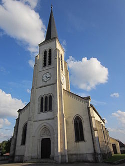
 "Nativité-de-la-Vierge" Church in Limey | |
| Coordinates: 48°53′13″N 5°53′45″E | |
| Country | France |
| Region | Grand Est |
| Department | Meurthe-et-Moselle |
| Arrondissement | Toul |
| Canton | Le Nord-Toulois |
| Intercommunality | Mad et Moselle |
| Government | |
| • Mayor (2020–2026) | Éliane Dubois[1] |
Area 1 | 18.33 km2 (7.08 sq mi) |
| Population (2022)[2] | 312 |
| • Density | 17/km2 (44/sq mi) |
| Time zone | UTC+01:00 (CET) |
| • Summer (DST) | UTC+02:00 (CEST) |
| INSEE/Postal code | 54316 /54470 |
| Elevation | 235–340 m (771–1,115 ft) (avg. 295 m or 968 ft) |
| 1 French Land Register data, which excludes lakes, ponds, glaciers > 1 km2 (0.386 sq mi or 247 acres) and river estuaries. | |
History
The origin of the name "Limey" is said to come from the Celtic word "lemos" meaning "elm [tree]". This particular tree was previously common in the area but has since disappeared.
The town has several memorials from the First World War. Remenauville is a former commune, whose village was totally destroyed during the First World War. Never rebuilt, it was attached to Limey in 1942. In 1962 the name Remenauville was added to that of Limey to form "Limey-Remenauville".[3][4]
See also
References
Wikiwand - on
Seamless Wikipedia browsing. On steroids.


