Le Pin-au-Haras
Commune in Normandy, France From Wikipedia, the free encyclopedia
Le Pin-au-Haras (French pronunciation: [lə pɛ̃ o aʁa] ⓘ) is a commune in the Orne department in north-western France.
Le Pin-au-Haras | |
|---|---|
 The chateau in Le Pin-au-Haras | |
Location of Le Pin-au-Haras  | |
 Le Pin-au-Haras  Le Pin-au-Haras | |
| Coordinates: 48°44′44″N 0°08′34″E | |
| Country | France |
| Region | Normandy |
| Department | Orne |
| Arrondissement | Argentan |
| Canton | Argentan-2 |
| Intercommunality | Terres d'Argentan Interco |
| Government | |
| • Mayor (2020–2026) | Christophe Beucher[1] |
Area 1 | 8.66 km2 (3.34 sq mi) |
| Population (2022)[2] | 253 |
| • Density | 29/km2 (76/sq mi) |
| Time zone | UTC+01:00 (CET) |
| • Summer (DST) | UTC+02:00 (CEST) |
| INSEE/Postal code | 61328 /61310 |
| Elevation | 140–248 m (459–814 ft) (avg. 240 m or 790 ft) |
| 1 French Land Register data, which excludes lakes, ponds, glaciers > 1 km2 (0.386 sq mi or 247 acres) and river estuaries. | |
Geography
Summarize
Perspective
The commune is made up of the following collection of villages and hamlets, La Lune, La Gautellerie, Courgeron, La Hamelinière, La Frênaie, Le Haras du Pin and Le Pin-au-Haras.[3]
The Commune is one of 27 communes that make up the Natura 2000 protected area of Bocages et vergers du sud Pays d'Auge.[4]
The commune has the River Ure running through it and five streams, the Etang des Genets, Etangs de Chagny, Chedouit, Pont de Barges & the Courgeron.
The commune is completely enclosed within the commune of Gouffern en Auge.[3]
Climate
Le Pin-au-Haras's Climate is classed as a temperate oceanic climate according to the Köppen–Geiger climate classification.[5]
| Climate data for Le Pin-au-Haras, 1991–2021 normals, elevation: 202 m (663 ft), extremes 1968–present, 1991 - 2019 Average sun hours | |||||||||||||
|---|---|---|---|---|---|---|---|---|---|---|---|---|---|
| Month | Jan | Feb | Mar | Apr | May | Jun | Jul | Aug | Sep | Oct | Nov | Dec | Year |
| Record high °C (°F) | 17.2 (63.0) |
19.5 (67.1) |
23.2 (73.8) |
26.9 (80.4) |
30 (86) |
34.9 (94.8) |
38.3 (100.9) |
37.2 (99.0) |
32.5 (90.5) |
27.8 (82.0) |
21.1 (70.0) |
15.9 (60.6) |
38.3 (100.9) |
| Mean daily maximum °C (°F) | 7.3 (45.1) |
8.3 (46.9) |
11.6 (52.9) |
14.7 (58.5) |
18 (64) |
21.4 (70.5) |
23.6 (74.5) |
23.6 (74.5) |
20.3 (68.5) |
15.6 (60.1) |
10.8 (51.4) |
7.8 (46.0) |
15.3 (59.5) |
| Daily mean °C (°F) | 4.3 (39.7) |
4.6 (40.3) |
7.1 (44.8) |
9.3 (48.7) |
12.7 (54.9) |
15.8 (60.4) |
17.7 (63.9) |
17.7 (63.9) |
14.7 (58.5) |
11.3 (52.3) |
7.4 (45.3) |
4.7 (40.5) |
10.6 (51.1) |
| Mean daily minimum °C (°F) | 1.2 (34.2) |
0.8 (33.4) |
2.5 (36.5) |
3.9 (39.0) |
7.4 (45.3) |
10.3 (50.5) |
11.9 (53.4) |
11.8 (53.2) |
9.1 (48.4) |
7.1 (44.8) |
4 (39) |
1.6 (34.9) |
6 (43) |
| Record low °C (°F) | −27.5 (−17.5) |
−16 (3) |
−12 (10) |
−7.1 (19.2) |
−4 (25) |
−2.2 (28.0) |
1.8 (35.2) |
−0.7 (30.7) |
−2.5 (27.5) |
−8 (18) |
−10 (14) |
−14 (7) |
−27.5 (−17.5) |
| Average precipitation mm (inches) | 66.7 (2.63) |
56.1 (2.21) |
55.3 (2.18) |
55.9 (2.20) |
66.7 (2.63) |
54 (2.1) |
58.9 (2.32) |
58.1 (2.29) |
53.9 (2.12) |
73.7 (2.90) |
75.4 (2.97) |
81.6 (3.21) |
756.3 (29.78) |
| Average precipitation days (≥ 1.0 mm) | 12.7 | 11.5 | 11.3 | 10.7 | 9.6 | 8.7 | 8.2 | 9.2 | 9 | 12.5 | 13.8 | 14.4 | 131.5 |
| Average relative humidity (%) | 87 | 83 | 79 | 74 | 74 | 71 | 70 | 72 | 76 | 82 | 88 | 87 | 79 |
| Mean monthly sunshine hours | 83.7 | 103.6 | 161.2 | 213 | 229.4 | 252 | 263.5 | 241.8 | 195 | 142.6 | 99 | 93 | 2,077.8 |
| Source 1: Météo France[6] | |||||||||||||
| Source 2: Climate data (relative humidity & Average Sunshine hours)[5] | |||||||||||||
Notable buildings and places
National heritage sites
Haras national du Pin is the national and oldest Stud farm of France, and considered the Versailles for horses.[7] It was created by Louis XIV and built in the 1700's.[8] It is now a tourist attraction and was listed as a Monument historique in 1948.[9]
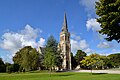 Église Notre-Dame de l'Assomption du Pin-au-Haras.
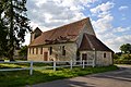 Ancienne église Saint-Ouen (Le Vieux Pin) du Pin-au-Haras

_du_Pin-au-Haras._Vue_sud-est.jpg)
See also
References
Wikiwand - on
Seamless Wikipedia browsing. On steroids.