Lage Zwaluwe
Village in North Brabant, Netherlands From Wikipedia, the free encyclopedia

Lage Zwaluwe is a village in the municipality Drimmelen, North Brabant, the Netherlands. The Lage Zwaluwe railway station and the Moerdijk bridges lie to the west of the village.
Lage Zwaluwe | |
|---|---|
Village | |
 St John the Baptist Church | |
 Lage Zwaluwe Location in the province of North Brabant in the Netherlands  Lage Zwaluwe Lage Zwaluwe (Netherlands) | |
| Coordinates: 51°42′29″N 4°42′12″E | |
| Country | Netherlands |
| Province | North Brabant |
| Municipality | Drimmelen |
| Area | |
• Total | 23.58 km2 (9.10 sq mi) |
| Elevation | 1.2 m (3.9 ft) |
| Population (2021)[1] | |
• Total | 4,110 |
| • Density | 170/km2 (450/sq mi) |
| Time zone | UTC+1 (CET) |
| • Summer (DST) | UTC+2 (CEST) |
| Postal code | 4926[1] |
| Dialing code | 0168 |
History
The village was first mentioned in as 1291 Zwaluwe, and means whirling, rushing river. Laag (lower) has been added by distinguish from Hooge Zwaluwe.[3] Lage Zwaluwe developed as a linear settlement along the dike of the Grote Hollandse Waard.[4]
The Dutch Reformed church dates from 1816 and was extended in 1867. The Catholic St John the Baptist church was built in 1951 and contains three 17th century Flemish paintings.[4]
Lage Zwaluwe was home to 1,241 people in 1840.[5] In 1866, the Lage Zwaluwe railway station opened. The original station building was destroyed in 1945. In 1950, a small building was constructed. It was demolished for the construction of HSL-Zuid, the high speed railway line. In 2003, a glass air bridge was built.[6]
Lage Zwaluwe used to be part of the municipality of Hooge en Lage Zwaluwe. In 1996, it was merged into Drimmelen.[5]
Gallery
 Clergy house
 Hotel
Hotel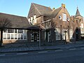 School
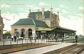 The old railway station


References
Wikiwand - on
Seamless Wikipedia browsing. On steroids.