Top Qs
Timeline
Chat
Perspective
Kuna Peak
Mountain peak in California, United States From Wikipedia, the free encyclopedia

Remove ads
Kuna Peak is a summit on the boundary between Mono and Tuolumne counties, in the United States,[3] is the highest point on Kuna Crest.[5] With an elevation of 13,008 feet (3,965 m), Kuna Peak is the 146th-highest summit in the state of California,[6][7] and is the third-highest mountain in Yosemite National Park.[8][9]

Remove ads
Name
The word Kuna probably derives from a Shoshonean word meaning "fire," appearing in the Mono dialect of the area, with a meaning of firewood.[10][11] On the summit, there are many jagged pieces of rock which resemble fire themselves; see Kuna Crest Granodiorite.
Geography
Summarize
Perspective
Kuna Peak is flanked by shorter peaks all of which are nearly equal in height, such as Koip Peak, which is a mile to the east, and is 40 feet (12 m) feet lower.[5] The western side of Kuna Peak is in Yosemite National Park, the eastern side being in the Ansel Adams Wilderness.[12]
The following features are near Kuna Peak:
- Alger Lakes
- Bingaman Lake
- Donohue Peak
- Koip Glacier
- Koip Peak
- Koip Peak Pass
- Helen Lake
- Kuna Lake
- Kuna Glacier
- Mammoth Peak
- Mono Pass
- Mount Andrea Lawrence
- Mount Lewis
- Parker Pass
- Parker Peak
- Spillway Lake
Climate
Remove ads
Gallery
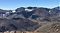 North aspect of Kuna Peak centered in the distance, as seen from Mount Gibbs.
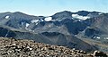 North aspects of Parker Peak (left), Koip Peak (right of center), and Kuna Peak (right) as seen from Mount Gibbs.


References
Wikiwand - on
Seamless Wikipedia browsing. On steroids.
Remove ads