Klojen
District in East Java, Indonesia From Wikipedia, the free encyclopedia
District in East Java, Indonesia From Wikipedia, the free encyclopedia
Klojen is a district in city of Malang, East Java, Indonesia.
Klojen | |
|---|---|
| Kecamatan Klojen | |
 Malang City Hall located in Klojen | |
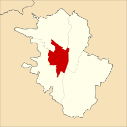
 Map of Malang with Klojen highlighted | |
| Coordinates: 7.976408°S 112.629378°E | |
| Country | |
| Province | |
| City | |
| Area | |
| • Total | 8.83 km2 (3.41 sq mi) |
| Elevation | 454 m (1,490 ft) |
| Population (2010) | |
| • Total | 105,907 |
| • Density | 12,000/km2 (31,000/sq mi) |
| Website | kecklojen |
Northern side of Klojen bordering with Lowokwaru and Blimbing subdistricts, eastern side bordering with Kedungkandang subdistrict, southern side bordering with Sukun subdistrict, and western side of Klojen bordering with the Sukun and Lowokwaru sub-districts.[1]
The climate in Klojen features tropical monsoon climate (Am) according to Köppen–Geiger climate classification system, as the climate precipitation throughout the year is greatly influenced by the monsoon, bordering with subtropical highland climate (Cwb). Most months of the year are marked by significant rainfall. The short dry season has little impact. The average temperature in Klojen is 23.7 °C. In a year, the average rainfall is 2090 mm.
| Climate data for Klojen, Malang (elevation 454 m or 1,490 ft) | |||||||||||||
|---|---|---|---|---|---|---|---|---|---|---|---|---|---|
| Month | Jan | Feb | Mar | Apr | May | Jun | Jul | Aug | Sep | Oct | Nov | Dec | Year |
| Mean daily maximum °C (°F) | 28.5 (83.3) |
28.5 (83.3) |
28.5 (83.3) |
28.6 (83.5) |
29 (84) |
28.8 (83.8) |
28.4 (83.1) |
29.3 (84.7) |
29.8 (85.6) |
30.2 (86.4) |
29.5 (85.1) |
28.5 (83.3) |
29.0 (84.1) |
| Daily mean °C (°F) | 24.1 (75.4) |
24.1 (75.4) |
24 (75) |
23.9 (75.0) |
23.9 (75.0) |
23.2 (73.8) |
22.4 (72.3) |
23.2 (73.8) |
23.6 (74.5) |
24.3 (75.7) |
24.3 (75.7) |
23.8 (74.8) |
23.7 (74.7) |
| Mean daily minimum °C (°F) | 19.7 (67.5) |
19.7 (67.5) |
19.5 (67.1) |
19.3 (66.7) |
18.9 (66.0) |
17.7 (63.9) |
16.5 (61.7) |
17.1 (62.8) |
17.5 (63.5) |
18.5 (65.3) |
19.2 (66.6) |
19.1 (66.4) |
18.6 (65.4) |
| Average precipitation mm (inches) | 335 (13.2) |
310 (12.2) |
293 (11.5) |
173 (6.8) |
132 (5.2) |
76 (3.0) |
46 (1.8) |
26 (1.0) |
44 (1.7) |
105 (4.1) |
224 (8.8) |
326 (12.8) |
2,090 (82.1) |
| Average relative humidity (%) | 81.7 | 82.3 | 82.2 | 79.2 | 79.8 | 77.3 | 75.1 | 72.9 | 70.9 | 70.9 | 74.4 | 79.1 | 77.1 |
| Source 1: Climate-Data.org (temp & precip)[2] | |||||||||||||
| Source 2: Weatherbase (humidity)[3] | |||||||||||||
Seamless Wikipedia browsing. On steroids.
Every time you click a link to Wikipedia, Wiktionary or Wikiquote in your browser's search results, it will show the modern Wikiwand interface.
Wikiwand extension is a five stars, simple, with minimum permission required to keep your browsing private, safe and transparent.