Top Qs
Timeline
Chat
Perspective
Kilindi District, Tanga
District of Tanga Region, Tanzania From Wikipedia, the free encyclopedia
Remove ads
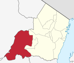
Kilindi is one of eleven administrative districts of Tanga Region in Tanzania. The District covers an area of 6,444 km2 (2,488 sq mi).[1] It is bordered to the east by the Handeni District and Handeni Town Council, to the south west by the Kiteto District and north west by the Simanjiro District of Manyara Region. Kilindi District is bordered to the south by Gairo District and Kilosa District of Morogoro Region. The district created from Handeni District in 2002. The district seat (capital) is the town of Songe. The district is home to Nguu Mountains. According to the 2022 census, the district has a total population of 398,391.[2][3]
Remove ads
Remove ads
Etymology and history
The Sambaa and Ngulu were the first inhabitants of the Kilindi district. Based in Vugha, who established the Shambaa Kingdom between the 18th and 20th centuries. Kilindi district is named after the Kilindi Dynasty that ruled over western Tanga in the 18-20th century. [4]
Administrative subdivisions
As of 2012, Kilindi District was administratively divided into 21 wards.[5]
Wards
References
Wikiwand - on
Seamless Wikipedia browsing. On steroids.
Remove ads

