Top Qs
Timeline
Chat
Perspective
Kars Parish, New Brunswick
Parish in New Brunswick, Canada From Wikipedia, the free encyclopedia
Remove ads
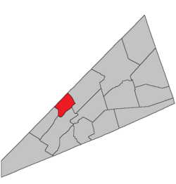
Kars is a geographic parish in Kings County, New Brunswick, Canada.[2]
Remove ads
Prior to the 2023 governance reform, it comprised the local service district of the parish of Kars,[3] which was a member of Kings Regional Service Commission (RSC8).[4]
Remove ads
Origin of name
The parish was named for the Siege of Kars, last major operation of the Crimean War.[5]
History
Kars was erected in 1860 from Greenwich and Springfield Parishes.[6]
In 1877 the islands in Belleisle Bay were added to Kars.[7]
Boundaries
Kars Parish is bounded:[2][8][9][10]
- on the northwest by the Queens County line;
- on the east by the eastern line of three grants, beginning on the county line about 900 metres northeast of the ends of Bond Road and McCrea Road, then running southeasterly, with two short doglegs, past Vail Road to strike Belleisle Bay about 450 metres east of the eastern end of Coreyvale Road;
- on the south by Belleisle Bay;
- on the west by the Saint John River;
- including Hog Island and Pig Island near the mouth of Belleisle Bay and Ghost Island in the bay.
Governance
Before 2023, the entire parish formed the local service district of the parish of Kars, established in 1968 to assess for fire protection. Recreational facilities were added in 2001 and non-fire related rescue in 2012. First aid and ambulance services (1972—2001) and community services (1986—2001) were formerly included.
Communities
Communities at least partly within the parish.[8][9][10]
|
|
Bodies of water
Islands
Islands at least partly in the parish.[8][9][10]
- Ghost Island
- Hog Island
- Pig Island
Demographics
Access Routes
Highways and numbered routes that run through the parish, including external routes that start or finish at the parish limits:[14]
See also
Notes
References
Wikiwand - on
Seamless Wikipedia browsing. On steroids.
Remove ads

