Karaman Eyalet
Administrative division of the Ottoman Empire from 1483 to 1864 From Wikipedia, the free encyclopedia
Karaman Eyalet (Ottoman Turkish: ایالت قرهمان, romanized: Eyālet-i Ḳaraman)[2] was one of the subdivisions of the Ottoman Empire. Its reported area in the 19th century was 30,463 square miles (78,900 km2).[3]
| ایالت قرهمان Eyālet-i Ḳaraman | |||||||||
|---|---|---|---|---|---|---|---|---|---|
| Eyalet of the Ottoman Empire | |||||||||
| 1483–1864 | |||||||||
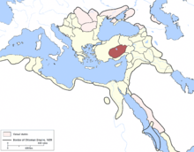
 The Karaman Eyalet in 1609 | |||||||||
| Capital | Konya (1483–1522), (1562–1864),[1] Kayseri (1522–1562) | ||||||||
| History | |||||||||
• Established | 1483 | ||||||||
• Disestablished | 1864 | ||||||||
| |||||||||
| Today part of | Turkey | ||||||||
In 1468, the formerly independent principality of Karaman was annexed by the Ottomans; Mehmed II appointed his son Mustafa as governor of the new eyalet, with his seat at Konya.[4]
Administrative divisions
The eyalet consisted of seven sanjaks between 1700 and 1740:[5] Konya, Niğde, Kayseri, Kırşehir, Beyşehir, Aksaray, and Akşehir.
References
See also
Wikiwand - on
Seamless Wikipedia browsing. On steroids.
