Kalpatti Island is an uninhabited island of Agatti atoll in Lakshadweep, India. There were plans to extend the runway of the airport on the nearby Agatti Island to Kalpati Island to accommodate jet aircraft.[3] The plans were rejected on environmental grounds because the proposed runway extension would have passed a turtle colony.[4]
 Kalpatti Island | |
| Geography | |
|---|---|
| Location | Arabian Sea |
| Coordinates | 10.813°N 72.167°E |
| Archipelago | Lakshadweep |
| Adjacent to | Indian Ocean |
| Total islands | 1 |
| Major islands |
|
| Area | 0.085 km2 (0.033 sq mi)[1] |
| Length | 0.4 km (0.25 mi) |
| Width | 0.25 km (0.155 mi) |
| Coastline | 1.5 km (0.93 mi) |
| Highest elevation | 1 m (3 ft) |
| Administration | |
| Territory | Union territory of Lakshadweep |
| District | Lakshadweep |
| Island group | Laccadive Islands |
| Tehsils of India | Kavaratti |
| Subdivisions of India | Agatti Island |
| Largest settlement | (None) |
| Demographics | |
| Population | 0 (2017) |
| Pop. density | 0/km2 (0/sq mi) |
| Ethnic groups | (None) |
| Additional information | |
| Time zone | |
| PIN | 68255x |
| Telephone code | 0489x |
| ISO code | IN-LD-06[2] |
| Official website | www |
| Avg. summer temperature | 32.0 °C (89.6 °F) |
| Avg. winter temperature | 28.0 °C (82.4 °F) |
| Sex ratio | 0♂/♀ |
Administration
The island belongs to the township of Agatti Island of Kavaratti Tehsil.[5]
Image gallery
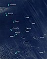 Satellite picture showing the atolls of the Lakshadweep except for Minicoy
 Map
Map


See also
References
Wikiwand in your browser!
Seamless Wikipedia browsing. On steroids.
Every time you click a link to Wikipedia, Wiktionary or Wikiquote in your browser's search results, it will show the modern Wikiwand interface.
Wikiwand extension is a five stars, simple, with minimum permission required to keep your browsing private, safe and transparent.