Top Qs
Timeline
Chat
Perspective
Jinning, Kinmen
Rural township in Fukien, Republic of China From Wikipedia, the free encyclopedia
Remove ads

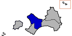
Jinning Township (Chinese: 金寧鄉; pinyin: Jīnníng Xiāng; Wade–Giles: Chin¹-ning² Hsiang¹; Pe̍h-ōe-jī: Kim-lêng-hiong) is a rural township in Kinmen, Republic of China. It is in the Taiwan Strait, on the coast of mainland China. It has a population of 34,569 (February 2023) and an area of 29.8540 km2 (11.5267 sq mi).[5]
Remove ads
History
In 1913, Sen-you Li (李森佑) founded the Guning Advanced Elementary School (古寧高等小學).[6][7]
In October 1949, today's Jinning Township was the site of the Battle of Kuningtou.[6]
Jinning Township was established in 1953.[8]
In 1999, the Kinmen County Government established a horseshoe crab conservation area of about 800 hectares in the tidal flat[9] northwest of Guningtou (Ku-ning-t'ou,[9] 古寧頭[9]).[6][7]
Remove ads
Administrative divisions

Jinning is divided into six rural villages:[6][7][10][11]
Education
Tourist attractions
Transportation
Jinning is connected to Lieyu / Lesser Kinmen by Kinmen Bridge.[13]
See also
References
Wikiwand - on
Seamless Wikipedia browsing. On steroids.
Remove ads


