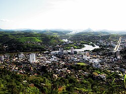
Itaperuna
Municipality in Southeast, Brazil From Wikipedia, the free encyclopedia
Itaperuna (Portuguese pronunciation: [itapeˈɾunɐ]) is a municipality in the Brazilian state of Rio de Janeiro. It had a population of 101,041 in 2022, and has an area of 1.105,3 km2.[2][3]
Itaperuna | |
|---|---|
| Município de Itaperuna | |
 | |
 Location of Itaperuna in the state of Rio de Janeiro | |
| Coordinates: 21°12′18″S 41°53′16″W | |
| Country | Brazil |
| Region | Southeast |
| State | Rio de Janeiro |
| Government | |
| • Prefeito | Marcus Vinícius de Oliveira Pinto (PR) |
| Area | |
• Total | 1,105.566 km2 (426.861 sq mi) |
| Elevation | 108 m (354 ft) |
| Population (2022 [1]) | |
• Total | 101,041 |
| • Density | 91/km2 (240/sq mi) |
| Time zone | UTC-3 (UTC-3) |
| Website | |
History
Itaperuna was founded in 1889, after being separated from the municipality of Campos dos Goytacazes.[4]
Location
Itaperuna is located 230 km from the state capital Rio de Janeiro. Its neighbouring municipalities are:[5]
- Bom Jesus do Itabapoana – north, northeast and east
- Campos dos Goytacazes – east
- Italva – east and southeast
- Cambuci – south
- São José de Ubá – south
- Miracema – southwest
- Laje do Muriaé – west
- Patrocínio de Muriaé – northwest
- Eugenópolis – northwest
- Antônio Prado de Minas – northwest
Climate
| Climate data for Itaperuna (1991–2020) | |||||||||||||
|---|---|---|---|---|---|---|---|---|---|---|---|---|---|
| Month | Jan | Feb | Mar | Apr | May | Jun | Jul | Aug | Sep | Oct | Nov | Dec | Year |
| Mean daily maximum °C (°F) | 33.0 (91.4) |
33.5 (92.3) |
32.2 (90.0) |
30.6 (87.1) |
28.4 (83.1) |
27.8 (82.0) |
27.9 (82.2) |
28.8 (83.8) |
29.9 (85.8) |
30.7 (87.3) |
30.4 (86.7) |
31.8 (89.2) |
30.4 (86.7) |
| Daily mean °C (°F) | 27.0 (80.6) |
27.1 (80.8) |
26.3 (79.3) |
24.8 (76.6) |
22.2 (72.0) |
21.0 (69.8) |
20.9 (69.6) |
21.8 (71.2) |
23.2 (73.8) |
24.5 (76.1) |
24.9 (76.8) |
26.1 (79.0) |
24.2 (75.6) |
| Mean daily minimum °C (°F) | 22.6 (72.7) |
22.5 (72.5) |
22.2 (72.0) |
20.7 (69.3) |
17.8 (64.0) |
16.3 (61.3) |
15.8 (60.4) |
16.4 (61.5) |
18.2 (64.8) |
20.1 (68.2) |
21.0 (69.8) |
22.1 (71.8) |
19.6 (67.3) |
| Average precipitation mm (inches) | 189.9 (7.48) |
120.0 (4.72) |
150.7 (5.93) |
68.8 (2.71) |
41.5 (1.63) |
21.3 (0.84) |
15.4 (0.61) |
21.3 (0.84) |
61.3 (2.41) |
89.8 (3.54) |
197.1 (7.76) |
227.5 (8.96) |
1,204.6 (47.43) |
| Average precipitation days (≥ 1.0 mm) | 11.1 | 8.0 | 9.5 | 6.3 | 4.7 | 2.5 | 2.6 | 3.1 | 4.7 | 6.9 | 12.5 | 13.8 | 85.7 |
| Average dew point °C (°F) | 22.3 (72.1) |
22.2 (72.0) |
22.2 (72.0) |
21.1 (70.0) |
18.8 (65.8) |
17.7 (63.9) |
16.8 (62.2) |
16.8 (62.2) |
17.8 (64.0) |
19.3 (66.7) |
20.7 (69.3) |
22.0 (71.6) |
19.8 (67.6) |
| Mean monthly sunshine hours | 217.8 | 221.1 | 207.2 | 194.2 | 189.9 | 186.5 | 197.8 | 211.5 | 184.7 | 183.1 | 159.3 | 185.2 | 2,338.3 |
| Source: NOAA[6] | |||||||||||||
Transportation
The city is served by Ernani do Amaral Peixoto Airport.
References
Wikiwand - on
Seamless Wikipedia browsing. On steroids.


