Loading AI tools
Region of Papua New Guinea From Wikipedia, the free encyclopedia
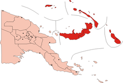
The New Guinea Islands Region is one of four regions of Papua New Guinea (PNG), comprising the Bismarck Archipelago and north-western Solomon Islands Archipelago, located north-east of New Guinea island (the mainland).
New Guinea Islands Region | |
|---|---|
 | |
| Coordinates: 4°21′S 152°16′E | |
| Country | |
| Largest city | Arawa |
| Area | |
| • Total | 56,602 km2 (21,854 sq mi) |
| Population (2011)[1] | |
| • Total | 1,096,543 |
| • Density | 19/km2 (50/sq mi) |
| Time zone | UTC+10:00 (PNGST) |
This is the least populous inhabited region of the country with an estimated population of 1,096,000 (15% of PNG) in 2011.[2]
It is distinct through its prehistory and history, as shown by the prevalence of Austronesian languages, and archeological findings of Lapita pottery culture.
The Region is administratively divided into five provinces:
Seamless Wikipedia browsing. On steroids.
Every time you click a link to Wikipedia, Wiktionary or Wikiquote in your browser's search results, it will show the modern Wikiwand interface.
Wikiwand extension is a five stars, simple, with minimum permission required to keep your browsing private, safe and transparent.