Intan Jaya Regency

Regency in Central Papua, Indonesia From Wikipedia, the free encyclopedia

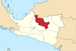
Intan Jaya Regencymap

Intan Jaya Regency is one of the regencies (kabupaten) in the Indonesian province of Central Papua; it was formed in 2008 from part of Paniai Regency. It covers an area of 3,922 km2, and had a population of 40,490 at the 2010 Census,[2] but this greatly increased to 135,043 at the 2020 Census;[3] the official estimate as at mid 2022 was 139,236.[1] The administrative centre is the town of Sugapa.

Quick Facts Kabupaten Intan Jaya, Country ...
Intan Jaya Regency
Kabupaten Intan Jaya
Thumb
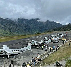
Bilorai Airport in Sugapa
Thumb
Motto(s): 
O Ndoma Dangge Inia Hanggia Dua Dia
(Seeing, Thinking and Working for All)
Thumb
Location in Central Papua
Thumb
Intan Jaya Regency
Location in Indonesian Papua
Thumb
Intan Jaya Regency
Location in Indonesia
Coordinates: 3.4102°S 136.7084°E / -3.4102; 136.7084
Country Indonesia
ProvinceCentral Papua
CapitalSugapa
Government
  RegentNatalis Tabuni
  Vice RegentYann Robert
Area
  Total
3,922.02 km2 (1,514.30 sq mi)
Population
 (mid 2022 estimate)[1]
  Total
139,236
  Density36/km2 (92/sq mi)
Time zoneUTC+9 (Indonesia Eastern Time)
Area code(+62) 901
Websiteintanjayakab.go.id
Close

Administrative Districts

Intan Jaya Regency comprised in 2010 six districts (distrik), tabulated below with their populations at the 2010 Census:[2]

More information Name ofDistrict (distrik), Pop'n 2010 Census ...
Name of
District
(distrik)
Pop'n
2010
Census
Homeyo11,848
Sugapa9,528
Hitadipa4,425
Agisiga5,631
Biandoga5,087
Wandai3,971
Close

By 2018, two further districts had been created - Tomosiga and Ugimba. The eight districts are tabulated below with their areas and their populations at the 2020 Census.[3] The table also includes the location of the district administrative centres, the number of administrative villages (all rated as rural kampung) in each district, and its post code.

More information Kode Wilayah, Name ofDistrict (distrik) ...
Kode
Wilayah
Name of
District
(distrik)
Area
in
km2
Pop'n
2020
Census
Admin
centre
No.
of
villages
Post
code
94.07.02Homeyo93824,482Pogapa2198791
94.07.01Sugapa62326,214Yokatapa1798793
94.07.07Ugimba2109,898Ugimba698794
94.07.06Hitadipa43516,427Hitadipa998792
94.07.05Agisiga38813,727Nabia1098782
94.07.08Tomosiga2088,978Tomosiga998783
94.07.04Biandoga87224,553Mbiandoga1698784
94.07.03Wandai24810,764Wandai998785
Totals3,922135,043Sugapa97
Close

References

Wikiwand - on

Seamless Wikipedia browsing. On steroids.