Top Qs
Timeline
Chat
Perspective
Inishturk
Island in County Mayo, Ireland From Wikipedia, the free encyclopedia

Remove ads
Inishturk (Inis Toirc in Irish, meaning Wild Boar Island) is an inhabited island of County Mayo, in Ireland.[4]

Remove ads
Geography

The island lies about 15 km (9 mi) off the coast; its highest point reaches 189.3 m (621.1 ft) above sea level.[2] Between Inisturk and Clare Island lies Caher Island. It has a permanent population of 58 people.[5] There are two main settlements, both on the more sheltered eastern end of the island, Ballyheer and Garranty. Bellavaun and Craggy are abandoned settlements.
Remove ads
History
Summarize
Perspective
Inishturk has been inhabited on and off since 4,000 BCE and has been inhabited permanently since at least 1700.[6] Some of the island's more recent inhabitants are descended from evacuees from Inishark to the southwest.[citation needed]
A Martello tower was built during the Napoleonic Wars, c. 1805, on Inishturk's western coast.[7]
Recent history
In 1993, Inishturk Community centre was opened, this community centre doubles as a library and a pub. In June 2014 the ESB commissioned three new Broadcrown BCP 110-50 100kVA diesel generators to supply electricity to the island.[8] The ESB have operated a diesel power station on the island since the 1980s.[9]
Inishturk gained international attention in 2016 after a number of websites claimed that the island would welcome any American "refugees" fleeing a potential Donald Trump presidency.[10][11][12] These were examples of the type of "fake news" that arose during the 2016 US presidential election campaign.[13]
The island is home to a primary school on the island which in 2011 had only 3 pupils; this is believed to be the smallest primary school in Ireland.[14]
Demographics
The table below reports data on Inisturk's population taken from Discover the Islands of Ireland (Alex Ritsema, Collins Press, 1999) and the Census of Ireland.
Remove ads
Transport
Prior to 1997 there was no scheduled ferry service and people traveled to and from the islands using local fishing boats. Since then a ferry service operates from Roonagh Quay, Louisburgh, County Mayo.[15] The pier was constructed during the 1980s by the Irish government, around this time the roads on the island were paved.[16]
Gallery
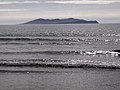 Inisturk and Caher island
 Inishturk pier
 Harbour with Caher Island in background
 Community centre
 Freshwater lake
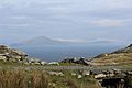 Clare Island as seen from Inishturk
 Power station


See also
References
External links
Wikiwand - on
Seamless Wikipedia browsing. On steroids.
Remove ads