Loading AI tools
Island within Ryukyu Islands From Wikipedia, the free encyclopedia
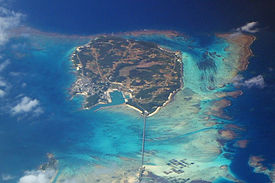
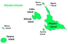
Ikema Island (池間島, Ikema-jima, Miyako: Ikyaama (イキャーマ)), is located to the north of Miyako Island in Okinawa Prefecture, Japan. The island is connected to Miyako Island with a 1,425-metre-long (4,675 ft) bridge (池間大橋), which was completed in February 1992.[3][1] There is a pond in the centre of the island. To the north-east is the Ikema-jima Block Beach (池間島ブロックビーチ). The variety of Miyakoan language spoken here is also called Ikema (Ikima in the vernacular). It is set apart from closely related language variants by its lexical word-tone system.[4]
This article needs additional citations for verification. (November 2011) |
Native name: Ikema-jima (池間島) | |
|---|---|
 Aerial view of Ikema-jima from southeast | |
 Ikema Island is located to the north of Miyako Island | |
| Geography | |
| Location | Okinawa Prefecture |
| Coordinates | 24°55′N 125°15′E |
| Archipelago | Miyako Islands |
| Area | 2.83 km2 (1.09 sq mi)[1] |
| Highest elevation | 28 m (92 ft) |
| Highest point | Unknown |
| Administration | |
Japan | |
| Demographics | |
| Population | 774[2] (2018) |
| Ethnic groups | Ryukyuan, Japanese |
Seamless Wikipedia browsing. On steroids.
Every time you click a link to Wikipedia, Wiktionary or Wikiquote in your browser's search results, it will show the modern Wikiwand interface.
Wikiwand extension is a five stars, simple, with minimum permission required to keep your browsing private, safe and transparent.