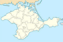
Hrushivka, Crimea
Village in Crimea From Wikipedia, the free encyclopedia
Hrushivka or Grushevka (Ukrainian: Грушівка; Russian: Грушевка) is a village in the Sudak Municipality of the Crimea, a territory recognized by a majority of countries as part of Ukraine and annexed by Russia as the Republic of Crimea.[2]
Hrushivka
Грушівка | |
|---|---|
 View of Hrushivka with the Crimean Mountains in the background. | |
| Coordinates: 45°01′06″N 34°58′20″E | |
| Republic | Crimea |
| Municipality | Sudak Municipality |
| First mentioned | 1778 |
| Area | |
• Total | 2.4 km2 (0.9 sq mi) |
| Elevation | 244 m (801 ft) |
| Population (2014) | |
• Total | 2,269 |
| • Density | 950/km2 (2,400/sq mi) |
| Time zone | UTC+4 (MSK) |
| Postal code | 98020 |
| Area code | +380 6566 |
| Website | http://rada.gov.ua/ |
Previously, the settlement was known as the Suuk-Sala village (Crimean Tatar: Suvuq Sala). Following the forced deportation of the Crimean Tatars in 1944, the Presidium of the Supreme Soviet of the Russian SFSR published a decree on May 18, 1948 renaming the settlement along with many others throughout Crimea from their native Crimean Tatar names to their current variants.[3]
Hrushivka is located on Crimea's southern shore at an elevation of 244 metres (801 ft).[1] Its population was 2,054 in the 2001 Ukrainian census.[2] Current population: 2,269 (2014 Census).[4]
References
External links
Wikiwand - on
Seamless Wikipedia browsing. On steroids.

