Hopeland, Western Australia
Suburb of Perth, Western Australia From Wikipedia, the free encyclopedia
Suburb of Perth, Western Australia From Wikipedia, the free encyclopedia
Hopeland is an outer suburb of the Western Australian capital city of Perth, located in the Shire of Serpentine-Jarrahdale. In the 2016 census, it had a population of 336 people.[3] It was established in 1923 as Group 46 of the Group Settlement Scheme on Peel Estate; the name was in use for some time and it was established as a suburb name on 1 May 1997.[4]
| Hopeland Perth, Western Australia | |||||||||||||||
|---|---|---|---|---|---|---|---|---|---|---|---|---|---|---|---|
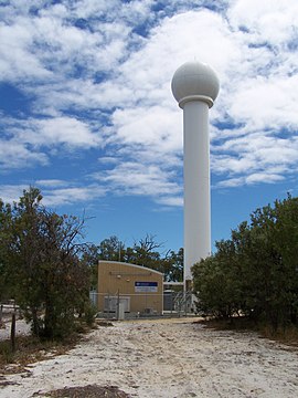
 Serpentine weather radar, Hopeland | |||||||||||||||
 | |||||||||||||||
| Coordinates | 32°23′17″S 115°51′4″E | ||||||||||||||
| Population | 313 (SAL 2021)[1] | ||||||||||||||
| Established | 1997 | ||||||||||||||
| Postcode(s) | 6125 | ||||||||||||||
| Area | 51.4 km2 (19.8 sq mi)[2] | ||||||||||||||
| Location | |||||||||||||||
| LGA(s) | Shire of Serpentine-Jarrahdale | ||||||||||||||
| State electorate(s) | Darling Range | ||||||||||||||
| Federal division(s) | Canning | ||||||||||||||
| |||||||||||||||
Seamless Wikipedia browsing. On steroids.
Every time you click a link to Wikipedia, Wiktionary or Wikiquote in your browser's search results, it will show the modern Wikiwand interface.
Wikiwand extension is a five stars, simple, with minimum permission required to keep your browsing private, safe and transparent.