Holm of Melby
Island in western Shetland, Scotland From Wikipedia, the free encyclopedia

Holm of Melby is a small uninhabited island off Mainland, Shetland in Scotland. It lies in the Sound of Papa just offshore from the settlement of Melby in the district of Sandness.[3][4]
| Meaning of name | small, rounded islet of Melby |
|---|---|
.jpg) View of the islet from Sandness | |
| Location | |
 Holm of Melby Holm of Melby shown within Scotland | |
| OS grid reference | HU 19375 58350 |
| Coordinates | 60°18′32″N 1°39′04″W |
| Physical geography | |
| Island group | Shetland |
| Area | c. 9 hectares (22.2 acres) |
| Area rank | na [1] |
| Highest elevation | 20 metres (66 ft) |
| Administration | |
| Council area | Shetland |
| Country | Scotland |
| Sovereign state | United Kingdom |
| Demographics | |
| Population | 0 |
| References | [2][3] |
It is less than a mile offshore from Melby and south-east of the nearby islands of Forewick Holm and Papa Stour. There is a natural arch on the north-west tip of the coastline.[3] It is part of the Sandness Coast SSSI, the main feature of which is its rocky shoreline.[5]
Cairns
There are three ancient cairns in ruins on the island. At the site of the south cairn a few large stone slabs are visible protruding through the turf. There is no sign of an internal chamber. The north-western most cairn, which has no "discernible features" is about 10 metres (33 ft) in diameter.
The cairn to the north-east is 19.5 metres (64 ft) in diameter and about 1.2 metres (4 ft) high. A group of three large stones suggest the presence of a chamber.[6]
Gallery
 The cliffs of the Holm from the village of Melby, with the southern cairn visible at the summit
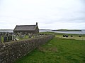 View from Melby churchyard


References
Wikiwand - on
Seamless Wikipedia browsing. On steroids.