Loading AI tools
From Wikipedia, the free encyclopedia
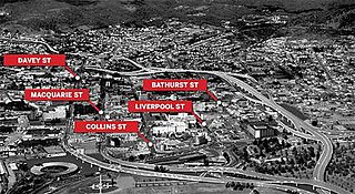
The Hobart Bypass is a proposed concept to bypass the Central Business District of Hobart, Tasmania. Currently, through traffic travels from the Tasman/Brooker Highways down the one-way Davey/Macquarie couplet to the Southern Outlet. As well as traffic concerns, there is also a call to build the bypass on the grounds that the current traffic arrangement cuts the central business district off from Hobart's waterfront.


At present, traffic proceeding to/from the Southern Outlet must pass through the one-way couplet of Davey and Macquarie Streets for access to the Tasman and Brooker highways. This current alignment was implemented in 1987 to coincide with the completion of the Sheraton. It was originally intended that the couplet system would serve as a stop gap measure prior to the construction of a freeway in Hobart's Transportation study of 1965.[1][2] Prior to this, all traffic in Hobart was 2-way.
The Northside Freeway was one of several traffic solutions proposed by US transportation and infrastructure consulting firm Wilbur Smith and Associates in their Hobart Area Transportation Study of 1965.[1] The proposed link was to extend from Grosvenor Street, Sandy Bay and the Southern Outlet at Davey Street and following the Hobart Rivulet and bypassing the CBD and crossing the Brooker Highway between Melville and Brisbane Streets, passing through the Queens Domain and connecting to the Tasman Highway.[1][3] The freeway was designed to be a raised freeway to avoid the sharp topographical features associated with the Queens Domain.[1]
There has since been several proposals for a tunnel[4] under the city:
This proposal was from Elboden St via a bridge over Hobart Rivulet into a tunnel to Knocklofty Terrace to Pottery Rd. Hobart transport economist Bob Cotgrove commented that this proposal was likely to be too peripheral to justify the expense.
In the past, a bypass of the CBD has been suggested from McRobies Gully, South Hobart via Knocklofty Park to Lenah Valley.[3] It has been pointed out that this proposal would be virtually useless to anyone wanting to access the CBD from the northern suburbs due to the significant detour required through Cascade Rd.
Several Councillors from the Huon Valley Council, the Derwent Valley Council and the Hobart City Council have advocated the upgrade of four-wheel drive tracks behind Mt Wellington (kunanyi) between the Huon Valley and the Derwent Valley, stating that it would decrease Hobart through-traffic. However it is 28km from the Huon Valley Council chambers to the Derwent Valley Council chambers via the proposed route, which makes it by far the furthest of any of the proposals. It is also certainly the most peripheral and would be the least used of any of the proposals. In May 2015, a report by consulting company Jacobs Australia stated that the proposed road provided only minor travel time savings, that accident rates would be higher and there would be a conflict between cars and trucks.[6]
For example, a car-park near the Mcvilly underpass of the Tasman Hwy that was cross-subsidised from CBD car-parks would remove some of the traffic that comes into the CBD via the Tasman Hwy.
Hobart ferry builder Bob Clifford has suggested a network of 17 ferry terminals. The state government announced in 2017 that it was considering a single peak-hour ferry crossing from Kangaroo Bay to Sullivans Cove.
Proposals include:
Hobart has built a network of bicycle tracks and recently commenced work on a pedestrian bridge across the Tasman Hwy just over a hundred metres from the existing underpass, with another planned for the Brooker Hwy a mere 50 metres or so from the existing pedestrian underpass. The Hobart City Council elected in 2014 appointed a five-member infrastructure committee made-up of four councillors who are aligned to the Tasmanian Greens. The Hobart City Council recently released a report advocating further measures to prioritise pedestrians and active transport. In 2010, Danish architect and urban designer Jan Gehl who was commissioned to write a report[7] which similarly advocated a prioritisation of pedestrians. Since that report, Liverpool St in Hobart has been converted to one lane, making it more difficult for cars to drive around the Elizabeth St Mall.
In early 2018 the Department of State Growth released a report[8] drafted together with Jacobs Consultants to widen the Southern Outlet by one lane through the Macquarie St and Davey St intersections and to add a lane to Macquarie St from Elboden St to Murray St. Under the proposal, Macquarie St would become one-way between Elboden St and Murray St, and the Southern Outlet and the new lane would be reserved for buses and left-turning traffic. The same report[8] also featured designs for a fifth lane (a reversible lane) for the Southern Outlet from Mt Nelson to Davey St.
Seamless Wikipedia browsing. On steroids.
Every time you click a link to Wikipedia, Wiktionary or Wikiquote in your browser's search results, it will show the modern Wikiwand interface.
Wikiwand extension is a five stars, simple, with minimum permission required to keep your browsing private, safe and transparent.