Hirakata
City in northeastern Osaka Prefecture, Japan From Wikipedia, the free encyclopedia
Hirakata (枚方市, Hirakata-shi) is a city in northeastern Osaka Prefecture, Japan.[2] As of 31 December 2021[update], the city had an estimated population of 397,681 in 183075 households and a population density of 6100 persons per km2.[3] The total area of the city is 65.12 square kilometres (25.14 sq mi).[3]
Hirakata
枚方市 | |
|---|---|
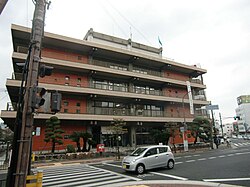
 Hirakata City hall | |
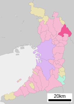
 Location of Hirakata in Osaka Prefecture | |
| Coordinates: 34°49′N 135°39′E | |
| Country | Japan |
| Region | Kansai |
| Prefecture | Osaka |
| Government | |
| • Mayor | Takashi Fushimi[1] |
| Area | |
• Total | 65.12 km2 (25.14 sq mi) |
| Population (December 31, 2021) | |
• Total | 397,681 |
| • Density | 6,100/km2 (16,000/sq mi) |
| Time zone | UTC+09:00 (JST) |
| City hall address | 2-1-20 Ogaito-chō, Hirakata-shi, Osaka-fu 573-8666 |
| Climate | Cfa |
| Website | Official website |
| Symbols | |
| Bird | Common kingfisher |
| Flower | Chrysanthemum |
| Tree | Willow |

Geography
Summarize
Perspective
Hirakata is located in northeastern of Osaka Prefecture, almost halfway between the metropolis of Osaka and Kyoto. It is on the left bank of the Yodogawa River, and forms a triangle of 12.0 km (7.5 mi) and 8.7 km (5.4 mi) north–south. It is bordered by the Ikoma Mountains to the east.
Neighboring municipalities
Kyoto Prefecture
Nara Prefecture
Osaka Prefecture
Climate
Hirakata has a Humid subtropical climate (Köppen Cfa) characterized by warm summers and cool winters with light to no snowfall. The average annual temperature in Hirakata is 16.2 °C (61.2 °F). The average annual rainfall is 1,389.5 mm (54.70 in) with June as the wettest month. The temperatures are highest on average in August, at around 28.3 °C (82.9 °F), and lowest in January, at around 4.9 °C (40.8 °F).[4]
| Climate data for Hirakata (1991−2020 normals, extremes 1977−present) | |||||||||||||
|---|---|---|---|---|---|---|---|---|---|---|---|---|---|
| Month | Jan | Feb | Mar | Apr | May | Jun | Jul | Aug | Sep | Oct | Nov | Dec | Year |
| Record high °C (°F) | 17.7 (63.9) |
22.7 (72.9) |
26.7 (80.1) |
31.0 (87.8) |
33.3 (91.9) |
36.4 (97.5) |
39.8 (103.6) |
39.6 (103.3) |
37.1 (98.8) |
34.0 (93.2) |
27.3 (81.1) |
25.0 (77.0) |
39.8 (103.6) |
| Mean daily maximum °C (°F) | 9.3 (48.7) |
10.2 (50.4) |
14.1 (57.4) |
20.1 (68.2) |
25.2 (77.4) |
28.1 (82.6) |
31.9 (89.4) |
33.7 (92.7) |
29.3 (84.7) |
23.5 (74.3) |
17.5 (63.5) |
11.8 (53.2) |
21.3 (70.3) |
| Daily mean °C (°F) | 4.9 (40.8) |
5.5 (41.9) |
8.9 (48.0) |
14.4 (57.9) |
19.4 (66.9) |
23.1 (73.6) |
27.1 (80.8) |
28.3 (82.9) |
24.3 (75.7) |
18.4 (65.1) |
12.5 (54.5) |
7.2 (45.0) |
16.2 (61.2) |
| Mean daily minimum °C (°F) | 1.0 (33.8) |
1.3 (34.3) |
4.2 (39.6) |
9.1 (48.4) |
14.4 (57.9) |
19.1 (66.4) |
23.4 (74.1) |
24.4 (75.9) |
20.4 (68.7) |
14.2 (57.6) |
8.1 (46.6) |
3.2 (37.8) |
12.0 (53.6) |
| Record low °C (°F) | −6.2 (20.8) |
−7.1 (19.2) |
−4.4 (24.1) |
−1.1 (30.0) |
3.2 (37.8) |
9.0 (48.2) |
15.3 (59.5) |
16.4 (61.5) |
9.4 (48.9) |
3.1 (37.6) |
−0.6 (30.9) |
−3.9 (25.0) |
−7.1 (19.2) |
| Average precipitation mm (inches) | 49.8 (1.96) |
61.6 (2.43) |
106.2 (4.18) |
102.4 (4.03) |
139.1 (5.48) |
194.2 (7.65) |
183.8 (7.24) |
142.5 (5.61) |
158.6 (6.24) |
136.7 (5.38) |
70.5 (2.78) |
53.0 (2.09) |
1,389.5 (54.70) |
| Average precipitation days (≥ 1.0mm) | 5.5 | 6.7 | 9.6 | 9.7 | 10.0 | 12.0 | 11.7 | 8.6 | 10.2 | 8.9 | 6.6 | 6.2 | 105.1 |
| Mean monthly sunshine hours | 135.0 | 128.7 | 161.2 | 184.4 | 193.4 | 141.7 | 155.9 | 204.9 | 153.9 | 158.1 | 143.2 | 139.9 | 1,912.2 |
| Source: Japan Meteorological Agency[4][5] | |||||||||||||
Demographics
Per Japanese census data,[6] the population of Hirakata rose rapidly in the 1960s and 1970s, and less rapidly since.
| Year | Pop. | ±% |
|---|---|---|
| 1920 | 23,714 | — |
| 1930 | 27,878 | +17.6% |
| 1940 | 39,306 | +41.0% |
| 1950 | 52,817 | +34.4% |
| 1960 | 80,312 | +52.1% |
| 1970 | 217,369 | +170.7% |
| 1980 | 353,358 | +62.6% |
| 1990 | 390,788 | +10.6% |
| 2000 | 402,563 | +3.0% |
| 2010 | 407,997 | +1.3% |
Eriko Aoki, author of "Korean children, textbooks, and educational practices in Japanese primary schools," stated that the city's location in proximity to both Osaka City and Kyoto contributed to its population growth of ten times its previous size from around 1973 to 2013.[7]
Ethnic Koreans
As of 2013 the city has about 2,000 ethnic Koreans. Most Hirakata Koreans,[8] including children of school age, use Japanese names.[9] Many Koreans in Hirakata operate their own businesses. Hirakata has the "mother's society" or "Omoni no Kai", a voluntary association of ethnic Korean mothers. It also has branches of the Chongryon and Mindan, Japan's two major Korean associations. Hirakata has no particular Korean neighborhoods.[8] There were about 3,000 ethnic Koreans in Hirakata in the pre-World War II period. In the 1930s Hirakata Koreans, fearful of keeping their own jobs, had negative attitudes towards Osaka-based Koreans who were looking for employment after having lost their jobs. Military construction was the most common job sector of that era's Korean population.[8] Eriko Aoki stated that in 2013 there was still a sense of difference between the Koreans in Hirakata and the Koreans in Osaka.[8]
History
The area of the modern city of Hirakata was within ancient Kawachi Province. The place name of "Hirakata" is very old, appearing in the Kojiki, Nihon Shoki and other ancient texts. During the Asuka period, the early Buddhist temple of Kudara-dera indicates the settlement of many immigrants from Baekje in the Korean Peninsula from an early time. During the Heian period, the hills from Katano to part of Hirakata were called "Katano ga Hara" and were a hunting ground for the imperial family and were famous for cherry blossoms. The Osaka Kaidō, an extension of the Tōkaidō highway passed through the area, and in the Edo Period Hirakata-juku developed as a post station on the highway and a river port on the Yodo River.
The Hirakata Town was established with the creation of the modern municipalities system on April 1, 1889. Hirakata was elevated to city status on August 1, 1947. On April 1, 2001, Hirakata was designated as a special city of Japan. On April 1, 2014, Hirakata became a Core city with increased local autonomy.
Government
Hirakata has a mayor-council form of government with a directly elected mayor and a unicameral city council of 32 members. Hirakata, together with neighboring Katano, contributes four members to the Osaka Prefectural Assembly. In terms of national politics, the city is part of Osaka 11th district of the lower house of the Diet of Japan.
Mayors
- Sōichirō Terashima (in office 1947 – 1955, 1959 – 1967) former mayor of Hirakata-chō
- Harufumi Hatakeyama (1955–1959)
- Tomizō Yamamura (1967–1975)
- Kazuo Kitamaki (1975–1991)
- Kazuo Ōshio (1991–1995)
- Hiroshi Nakatsuka (1995–2007)
- Osamu Takeuchi (2007–2015)
- Takashi Fushimi (2015–present)
Economy
Hirakata's modern industry began with the munitions industry supplying to the Imperial Japanese Army and numerous civilian textile and clothing manufacturers. In early March 1939, a site associated with the arms industry blew up, killing 500 people.[10] In the post-war era, the former munitions plants were transformed into industrial parks, or public housing complexes to support Hirakata's growth as a commuter town for Osaka and Kyoto. Textile and clothing production remain major industries in Hirakata.
Companies with offices in Hirakata
- Komatsu Osaka plant
- Sanyo Electric Co R&D
Education
Summarize
Perspective
Colleges and universities
Primary and secondary education
Hirakata has 45 public elementary schools and 19 public middle schools operated by the city government and six public high schools operated by the Osaka Prefectural Department of Education, and one by Osaka City. There is also one private elementary school, two private middle schools and three private high schools. The prefecture also operates two special education schools for the handicapped.
Prefectural senior high schools
- Hirakatsuda High School (大阪府立枚方津田高等学校)
- Korigaoka High School (大阪府立香里丘高等学校)
- Osaka Prefectural Hirakata High School (大阪府立枚方高等学校)
- Osaka Prefectural Makino High School (大阪府立牧野高等学校)
- Osaka Prefectural Nagao High School (大阪府立長尾高等学校)
- Hirakata Nagisa High School (大阪府立枚方なぎさ高等学校)
Municipal high schools
- Osaka City Senior High School (大阪市立高等学校) – In Hirakata
Private senior high schools:
- Josho Keiko Gakuen Junior and Senior High School (常翔啓光学園高等学校)
- Tokai University Gyosei Junior and Senior High School (東海大学付属仰星高等学校)
- Toyo Gakuen Nagaodani High School (長尾谷高等学校)
Transportation

Railway
![]() JR West – Katamachi Line (Gakkentoshi Line)
JR West – Katamachi Line (Gakkentoshi Line)
![]() Keihan Electric Railway - Keihan Main Line
Keihan Electric Railway - Keihan Main Line
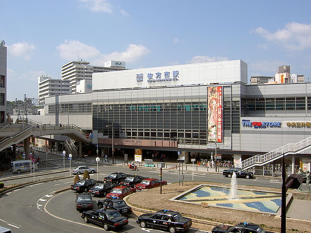
- Kōzenji - Hirakata-kōen - Hirakata-shi - Goten-yama - Makino - Kuzuha
Highway
 Second Keihan Highway
 National Route 1 Daini Keihan Road (toll road)
 National Route 168
 National Route 170
 National Route 307
Internationl relations
 Shimanto, Kōchi, Japan, friendship city agreement since 1974 (with former Nakamura city)
 Betsukai, Hokkaidō, Japan, friendship city agreement since 1987
 Takamatsu, Kagawa, Japan, friendship city agreement since 1987 (with former Shionoe town)
 Changning District, Shanghai, China, sister city agreement since 1987
 Logan City, Queensland, Australia, sister city agreement since 1995
Local attractions

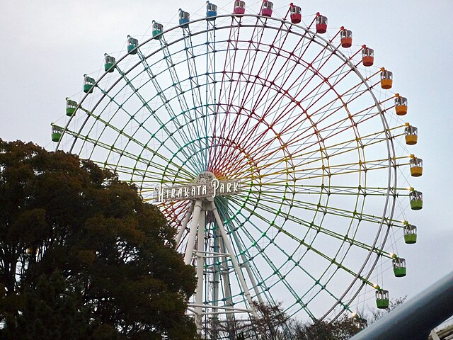
- Hirakata Park, an amusement park that includes roller coasters made of wood.[11]
- Hirakata T-Site, containing a Tsutaya bookstore with 7-meter (23 ft) high bookshelves.[12]
- Kudara-dera ruins
- Kinyakurumazuka Kofun
- Kuzuha Battery Site
Notable people from Hirakata
- Hikaru Nakamura, Japanese American chess player
- Janne Da Arc, Japanese visual kei rock band
- Iori Kogawa, Japanese AV Idol
- Koichiro Yoshinaga, Japanese former Nippon Professional Baseball catcher/infielder
- Airi Shimizu, Japanese gravure idol, actress and variety tarento
- Yuji Naka, Japanese video game programmer, designer, and producer who made Sonic the Hedgehog
- Satoshi Hashimoto, Japanese actor and voice actor
- Nobukazu Takemura, Japanese musician and artist
- Haruto Shirai, Japanese football player
- Kenji Honnami, former Japanese football player
- Yuki Kuniyoshi, professional Japanese baseball player
- Junichi Okada, singer, actor and member of popular Japanese boy band V6
- Katsuhisa Inamori, former Japanese football player
- Midori, Japanese American violinist and classical musician
- Kenji Moriwaki, Japanese comedian and radio personality
- Masahito Noto, Japanese football player
- Hirofumi Mukai, Japanese professional boxer
- Yohei Takeda, Japanese football player and goalkeeper
- Hisaya Morishige, Japanese actor and comedian
- Yuji Hino, Japanese professional wrestler
- Yuka Ishii, Japanese writer
- Takayuki Fukumura, Japanese football player
- Yoshimitsu Takashima, Japanese politician of the Democratic Party of Japan, a member of the House of Councillors in the Diet (national legislature)
- Takumi Ozaki, member of INI (Japanese boy group)
- Hono Tamura, member of Sakurazaka46
- Keiya Sento, Japanese football player, currently plays for Machida Zelvia
References
External links
Wikiwand - on
Seamless Wikipedia browsing. On steroids.


