Loading AI tools
Highway in Ukraine From Wikipedia, the free encyclopedia
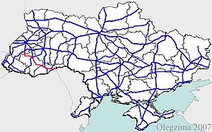
H10 is an important Ukraine national highway (H-highway) in Lviv, Ivano-Frankivsk, and Chernivtsi Oblasts.
| Highway H10 | ||||
|---|---|---|---|---|
| Автошлях Н10 | ||||
 | ||||
| Major junctions | ||||
| Northwest end | Stryi | |||
| Southeast end | Mamalyha | |||
| Location | ||||
| Country | Ukraine | |||
| Oblasts | Lviv, Ivano-Frankivsk Oblast, Chernivtsi | |||
| Highway system | ||||
| ||||
H10 belonged to the Kingdom of Galicia and Lodomeria until 1918 and was known as the Beskydy Reichsstraße. In 1817, it was built as the second east-west connection leading from Bielsko-Biała to Chernivtsi and was initially referred to as the Carpathian Road.[1] In 1893, there were 21 toll booths on the 260-kilometer stretch between Stryi and Chernivtsi.[2]
The stretch from Stryi to Stanislaviv (former name of Ivano-Frankivsk) belonged to the territory of the Second Polish Republic between 1918 and 1939 and was declared a state road (droga państwowa) by the Polish Roads Act of 10 December 1920.[3]
Seamless Wikipedia browsing. On steroids.
Every time you click a link to Wikipedia, Wiktionary or Wikiquote in your browser's search results, it will show the modern Wikiwand interface.
Wikiwand extension is a five stars, simple, with minimum permission required to keep your browsing private, safe and transparent.