Loading AI tools
Suburb of Sydney, New South Wales, Australia From Wikipedia, the free encyclopedia
Hebersham is a suburb of Sydney, in the state of New South Wales, Australia. Hebersham is located 47 kilometres west of the Sydney central business district, in the local government area of the City of Blacktown and is part of the Greater Western Sydney region.
| Hebersham Sydney, New South Wales | |||||||||||||||
|---|---|---|---|---|---|---|---|---|---|---|---|---|---|---|---|
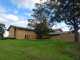
 LDS Church on Pringle Road | |||||||||||||||
 | |||||||||||||||
| Population | 5,643 (2021 census)[1] | ||||||||||||||
| Postcode(s) | 2770 | ||||||||||||||
| Elevation | 60 m (197 ft) | ||||||||||||||
| Location | 47 km (29 mi) W of Sydney CBD | ||||||||||||||
| LGA(s) | City of Blacktown | ||||||||||||||
| State electorate(s) | Mount Druitt | ||||||||||||||
| Federal division(s) | Chifley | ||||||||||||||
| |||||||||||||||
Hebersham was coined to honour the Anglican Bishop Reginald Heber of Calcutta whose diocese included New South Wales. In 1829 the Trustees of the Clergy and Schools Lands in New South Wales planned to establish a village named Hebersham on the Western Highway, west of Eastern Creek. This never happened, but the name was used for this present day suburb.[2]
According to the 2021 census of Population, there were 5,643 people in Hebersham.
Hebersham is also home to Hebersham Public School, a primary school founded in 1972.[3]
Heber Park is a large recreational park in the centre of Hebersham. It contains several sports fields, a basketball court, playgrounds, and off-leash dog parks. The park has basic facilities such as goalposts, shelters, and field lighting to support local-level sports.[4]
Seamless Wikipedia browsing. On steroids.
Every time you click a link to Wikipedia, Wiktionary or Wikiquote in your browser's search results, it will show the modern Wikiwand interface.
Wikiwand extension is a five stars, simple, with minimum permission required to keep your browsing private, safe and transparent.