Top Qs
Timeline
Chat
Perspective
Hajhir Mountains
Mountain range situated on the island of Socotra, Yemen From Wikipedia, the free encyclopedia

Remove ads
The Hajhir Mountains is a mountain range situated on the island of Socotra, Yemen. The mountain range reaches a height of 1,519 meters (4,984 ft) at Mount Scand, which is the tallest point of the island. There are 50 species on Socotra that are only found in the mountains. The mountain range has one of the highest density of endemic plants in southwest Asia and has a rural population.
.jpg)

Remove ads
Geography
The Hajhir Mountains mountains are located on the island of Socotra, an island belonging to Yemen,[1] which broke off from the mainland 18 million years ago The Hajhir Mountains were created by volcanic activity. The mountains are the watershed of Socotra.[2]
Mount Scand is the highest point of the mountains[3] at 1,519 meters (4,984 ft) above sea level. The Hajhir massif is composed of granite and metamorphic rock.[4] The northern face of the mountains have sheer cliffs while the southern and eastern faces have a slope.[5] The cliffs of the northern face reach 400 to 600 metres in height.[2]
Remove ads
Environment
Socotra is noted for its unique and endemic species.[1][2] 100 of Socotra's indigenous species are found in the mountains and 50 of these are only on the mountains. Dracaena cinnabari and[2] Carex socotrana are found on the mountains.[6] The mountains has one of the highest density of endemic plants in southwest Asia.[1]
The area of the island in the shadow of the Hajhir Mountains experience more aridity. The peak of the mountains have an average rainfall of 300 mm greater than the lower areas.[7]
Remove ads
Population
A rural population led by muqaddam inhabit the mountain range.[1]
Gallery
 The twin peaks of Mashanig. The fallen pillar bridging the peaks is called "Mishifo". The left-hand tower is the highest point of the range.
 Mount Skand
 Hajhir Mountains
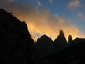
 Golden hour in Socotra, Yemen


.jpg)

See also
References
Works cited
Wikiwand - on
Seamless Wikipedia browsing. On steroids.
Remove ads