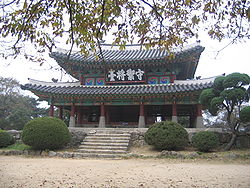
Gwangju, Gyeonggi
City in Gyeonggi, South Korea From Wikipedia, the free encyclopedia
City in Gyeonggi, South Korea From Wikipedia, the free encyclopedia
Gwangju[a] (Korean: 광주; Korean pronunciation: [kwaŋ.dʑu]) is a city in Gyeonggi Province, South Korea, a suburb southeast of Seoul. The city is not to be confused with the much larger Gwangju, former capital of South Jeolla Province, or Guangzhou, the city of Guangdong, China in Hanja.
Gwangju
광주시 | |
|---|---|
| Korean transcription(s) | |
| • Hangul | 광주시 |
| • Hanja | 廣州市[1] |
| • Revised Romanization | Gwangju-si |
| • McCune–Reischauer | Kwangju-si |
 | |
 Location in South Korea | |
| Country | |
| Region | Gyeonggi Province (Sudogwon) |
| Administrative divisions | 2 eup, 10 dong, 4 myeon |
| Government | |
| • mayor | Sehwan Bang (방세환) |
| Area | |
• Total | 430.99 km2 (166.41 sq mi) |
| Population (September 2024[2]) | |
• Total | 396,055 |
| • Density | 920/km2 (2,400/sq mi) |
| • Dialect | Seoul |
Bunwon-ri in Gwangju took an important role of ceramic production during the Kingdom of Joseon. There had official kilns and produced superb quality of white porcelains for use at the royal court and to export to China.[4]
In 1962, 4 myeons (townships) including 5 ris (villages) were incorporated to Seoul.[5]
In 1973, 6 ris were separated and became a part of Seongnam city. In 1979, Gwangju-myeon was elevated to an eup. Gwangju county became a city in 2001.[6]
Gwangju Toechon Tomato Festival - Gwangju City, Gyeonggi Province has been holding a festival since 2003 to promote the city's pollution-free tomatoes and sell them to consumers.
Gwangju has a monsoon-influenced humid continental climate (Köppen: Dwa) with cold, dry winters and hot, rainy summers.
| Climate data for Gwangju, Gyeonggi (1993–2020 normals) | |||||||||||||
|---|---|---|---|---|---|---|---|---|---|---|---|---|---|
| Month | Jan | Feb | Mar | Apr | May | Jun | Jul | Aug | Sep | Oct | Nov | Dec | Year |
| Mean daily maximum °C (°F) | 2.2 (36.0) |
5.4 (41.7) |
11.7 (53.1) |
18.6 (65.5) |
23.9 (75.0) |
27.8 (82.0) |
29.2 (84.6) |
30.2 (86.4) |
26.0 (78.8) |
20.0 (68.0) |
11.9 (53.4) |
3.9 (39.0) |
17.6 (63.7) |
| Daily mean °C (°F) | −3.3 (26.1) |
−0.4 (31.3) |
5.3 (41.5) |
11.8 (53.2) |
17.2 (63.0) |
21.8 (71.2) |
24.7 (76.5) |
25.2 (77.4) |
20.2 (68.4) |
13.3 (55.9) |
6.1 (43.0) |
−1.4 (29.5) |
11.7 (53.1) |
| Mean daily minimum °C (°F) | −8.2 (17.2) |
−5.7 (21.7) |
−0.5 (31.1) |
5.5 (41.9) |
11.2 (52.2) |
16.8 (62.2) |
21.2 (70.2) |
21.6 (70.9) |
16.0 (60.8) |
8.2 (46.8) |
1.0 (33.8) |
−6.1 (21.0) |
6.8 (44.2) |
| Average precipitation mm (inches) | 16.6 (0.65) |
25.0 (0.98) |
35.5 (1.40) |
67.5 (2.66) |
91.4 (3.60) |
118.1 (4.65) |
374.4 (14.74) |
317.6 (12.50) |
140.5 (5.53) |
55.9 (2.20) |
45.8 (1.80) |
19.8 (0.78) |
1,308.1 (51.50) |
| Average precipitation days (≥ 0.1 mm) | 3.4 | 3.5 | 5.3 | 6.8 | 6.6 | 7.6 | 12.9 | 13.0 | 7.5 | 5.2 | 6.8 | 4.8 | 83.4 |
| Source: Korea Meteorological Administration[7] | |||||||||||||
Seamless Wikipedia browsing. On steroids.
Every time you click a link to Wikipedia, Wiktionary or Wikiquote in your browser's search results, it will show the modern Wikiwand interface.
Wikiwand extension is a five stars, simple, with minimum permission required to keep your browsing private, safe and transparent.