Loading AI tools
River in the Caucasus From Wikipedia, the free encyclopedia
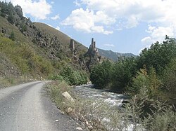
Guloykhi, or Guloy-khi (Ingush: ГӀулой-Хий, romanized: Ghuloy-Khiy) is a river in the Dzheyrakhsky District of the Republic of Ingushetia, a right tributary of the Assa River.[1][2]
| Guloykhi | |
|---|---|
 | |
| Native name | ГӀулой-хи (Ingush) |
| Location | |
| Country | Russian Federation |
| Region | Caucasus |
| Federal subject | Ingushetia |
| Physical characteristics | |
| Source | |
| • coordinates | 42°48′48″N 45°11′23″E |
| Mouth | Assa River |
• location | 103 km on the right bank |
• coordinates | 42°48′20″N 44°56′09″E |
• elevation | 1,112 m (3,648 ft) |
| Length | 24 km |
| Basin size | 161 km2 (62 sq mi) |
The Guloykhi river originates in the eastern part of mountainous Ingushetia. It flows west along a mountain valley near several medieval tower settlements, most notably Gul, Läzhg, Qoyrakh, Abali, Vovnushki, Koki, and flows into the Assa near Puy and Tkhaba-Yerdy.[3] A forest mainly covers the left bank of the river.[4] The speed of the flow is 2.2 m/s. The mouth of the river is located 103 km along the right bank of the Assa at an altitude of 1112 meters above sea level.
Seamless Wikipedia browsing. On steroids.
Every time you click a link to Wikipedia, Wiktionary or Wikiquote in your browser's search results, it will show the modern Wikiwand interface.
Wikiwand extension is a five stars, simple, with minimum permission required to keep your browsing private, safe and transparent.